Home
Main navigation
  • Mega Menu Icon
    Image
    case study icon
    Browse Case Studies
    • Filtered by hazard
      • Drought
      • Extreme Heat
      • Coastal Flooding
      • Flooding
      • Wildfire
    • Filtered by asset
      • Agriculture
      • Community Services
      • Critical Facilities
      • Economy
      • Energy
      • People
      • Property
      • Natural Areas
      • Transportation
      • Water Infrastructure
  • Mega Menu Icon
    Image
    data and tools icon
    Browse Tools
    • Filtered by hazard
      • Drought
      • Extreme Heat
      • Coastal Flooding
      • Flooding
      • Wildfire
    • Filtered by asset
      • Agriculture
      • Community Services
      • Critical Facilities
      • Economy
      • Energy
      • People
      • Property
      • Natural Areas
      • Transportation
      • Water Infrastructure
  • Mega Menu Icon
    Image
    funding icon
    Browse Funding & Capacity
    • Funding & Building Capacity
    • Search for Funding Opportunities
    • Grant Development Resources
    • Overview
    • Get Started
    • Understand Exposure
    • Assess Vulnerability & Risk
    • Investigate Options
    • Prioritize & Plan
    • Take Action
  • Mega Menu Icon
    Image
    popular resources icon
    Browse Popular Resources
    • Announcements
    • Steps to Resilience
    • Help Desk
    • Glossary
    • Contact
    • Case Studies
    • Tools
    • Trainings
    • Options Database
    • Organizations
    • New to the Toolkit?
    • Topics & Sectors
    • Regions
    • Hazards
    • Assets

Breadcrumb

  1. Home
  2. Options Database
Option

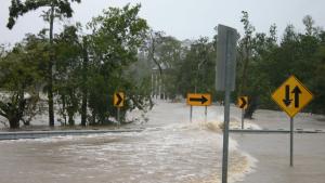
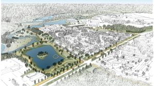
Obtain easements on properties at risk of flooding and use those areas for water retention and drainage.

Details

Hazards
Flooding – Coastal
Flooding – General
Assets
Property
Actions
Land Use Practice

Plans That List This Option

Image
HUD Community Resilience Toolkit cover
HUD Community Resilience Toolkit
Browse Case Studies

Case studies with the same hazard/asset combination

Related Case Studies

Image
View of downtown Portland, ME
Coastal Community Resilience in Maine
Image
State of NC plan cover
NC Climate Risk Assessment and Resilience Plan
Image
  • Charles Powell, public domain.

  • Mandeville, Louisiana: A City that Stays Afloat by Promoting Elevations
    Image
  • NOAA Office of Coastal Management, via Waggonner & Ball

  • Resiliency Officer Helps Design An Environmental Impact Bond To Finance Community Resilience Projects
    Grid view

    Action plans with the same hazard/asset combination

    Related Action Plans

    Image
    Tybee-Island-plan-cover
    Tybee Island Sea Level Rise Adaptation Plan
    Image
    USFWS National Fish, Wildlife, and Plants Climate Adaptation Strategy
  • Cover credits: Children in woods, Steve Hillebrand. Horse-eye jacks, National Oceanic and Atmospheric Administration. Painted Hills, Jane Pellicciotto. Pelican, George Andrejko/ Arizona Game and Fish Department

  • USFWS National Fish, Wildlife, and Plants Climate Adaptation Strategy
    Image
    city of seattle plan cover
  • Seattle Office of Sustainability & Environment

  • City of Seattle, WA: Preparing for a Changing Climate
    Image
    climate resilient san diego cover
  • City of San Diego

  • Climate Resilient San Diego
    Grid view
    Browse All Options

    Climate.gov
    • News & Features
    • Teaching Climate
    • Maps & Data
    • FAQs
    Main Menu
    • About
    • FAQ
    • Contact
    • Acknowledgments
    • Sitemap
    Latest
    • Funding Opportunities
    • Glossary
    • Announcements
    Partners
    • climate.data.gov
    • climate.gov
    • USA.gov
    • NEMAC
    Toolkit
    • Case Studies
    • Tools
    • Funding
    • Steps to Resilience
    • Popular Resources

    Climate Resilience Toolkit home link

    Required Footer Links
    • NOAA Privacy
    • Accessibility
    • FOIA
    • Information Quality
    • No-FEAR Act
    • Ready.gov
    • USA.gov