Home
Main navigation
  • Mega Menu Icon
    Image
    case study icon
    Browse Case Studies
    • Filtered by hazard
      • Drought
      • Extreme Heat
      • Coastal Flooding
      • Flooding
      • Wildfire
    • Filtered by asset
      • Agriculture
      • Community Services
      • Critical Facilities
      • Economy
      • Energy
      • People
      • Property
      • Natural Areas
      • Transportation
      • Water Infrastructure
  • Mega Menu Icon
    Image
    data and tools icon
    Browse Tools
    • Filtered by hazard
      • Drought
      • Extreme Heat
      • Coastal Flooding
      • Flooding
      • Wildfire
    • Filtered by asset
      • Agriculture
      • Community Services
      • Critical Facilities
      • Economy
      • Energy
      • People
      • Property
      • Natural Areas
      • Transportation
      • Water Infrastructure
  • Mega Menu Icon
    Image
    funding icon
    Browse Funding & Capacity
    • Funding & Building Capacity
    • Search for Funding Opportunities
    • Grant Development Resources
    • Overview
    • Get Started
    • Understand Exposure
    • Assess Vulnerability & Risk
    • Investigate Options
    • Prioritize & Plan
    • Take Action
  • Mega Menu Icon
    Image
    popular resources icon
    Browse Popular Resources
    • Announcements
    • Steps to Resilience
    • Help Desk
    • Glossary
    • Contact
    • Case Studies
    • Tools
    • Trainings
    • Options Database
    • Organizations
    • New to the Toolkit?
    • Topics & Sectors
    • Regions
    • Hazards
    • Assets

Breadcrumb

  1. Home
  2. Options Database
Option

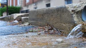
Improve road drainage around waterbodies and waterways to reduce stormwater runoff and erosion.

Details

Hazards
Water Quality
Erosion and Shoreline Recession
Assets
Water Infrastructure – Stormwater
Actions
Elevate Roads

Plans That List This Option

Image
Vermont-plan-cover
Vermont Climate Action Plan
Browse Case Studies

Case studies with the same hazard/asset combination

Related Case Studies

Image
  • Aerial view of the City of Virginia Beach oceanfront. © City of Virginia Beach, Department of Public Works. Used with permission

  • Virginia Beach Becomes Sea Level Wise
    Image
  • Si'u Point Trail, Ta'u Island, National Park of American Samoa, Department of the Interior, via Flickr. Used via a Creative Commons license, CC BY-SA 2.0, https://creativecommons.org/licenses/by-sa/2.0/

  • Collaborating for Success: Sustaining Water Supply on a Pacific Island
    Image
  • Stormwater flows onto street in Annapolis, Maryland. Photo courtesy of Chesapeake Bay Program (stretched), CC BY-NC 2.0, https://creativecommons.org/licenses/by-nc/2.0/, via Flickr

  • Improving Water Quality by Dealing with the First Inch of Rain
    Image
  • Marin Carbon Project

  • Ranchers in Marin County Consider Carbon Credits
    Grid view

    Action plans with the same hazard/asset combination

    Related Action Plans

    Image
    charlotte flood risk assessment plan cover
    Charlotte, NC Flood Risk Assessment and Reduction Community Guidebook
    Image
    California Adaptation Planning Guide cover
  • The California Governor's Office of Emergency Services

  • Statewide Summary Report: California's Fourth Climate Change Assessment
    Grid view
    Browse All Options

    Climate.gov
    • News & Features
    • Teaching Climate
    • Maps & Data
    • FAQs
    Main Menu
    • About
    • FAQ
    • Contact
    • Acknowledgments
    • Sitemap
    Latest
    • Funding Opportunities
    • Glossary
    • Announcements
    Partners
    • climate.data.gov
    • climate.gov
    • USA.gov
    • NEMAC
    Toolkit
    • Case Studies
    • Tools
    • Funding
    • Steps to Resilience
    • Popular Resources

    Climate Resilience Toolkit home link

    Required Footer Links
    • NOAA Privacy
    • Accessibility
    • FOIA
    • Information Quality
    • No-FEAR Act
    • Ready.gov
    • USA.gov