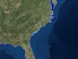
Sea Level Rise Viewer
A web mapping tool to visualize community-level impacts from coastal flooding or sea level rise.
Drupal\Component\PhpStorage\FileStorage->createDirectory() (Line: 73)
Drupal\Component\PhpStorage\FileStorage->ensureDirectory() (Line: 66)
Drupal\Component\PhpStorage\MTimeProtectedFastFileStorage->save() (Line: 115)
Drupal\Core\Template\TwigPhpStorageCache->write() (Line: 410)
Twig\Environment->loadTemplate() (Line: 370)
Twig\Environment->load() (Line: 33)
twig_render_template() (Line: 348)
Drupal\Core\Theme\ThemeManager->render() (Line: 490)
Drupal\Core\Render\Renderer->doRender() (Line: 248)
Drupal\Core\Render\Renderer->render() (Line: 165)
Drupal\Core\Render\Renderer->{closure:Drupal\Core\Render\Renderer::renderInIsolation():164}() (Line: 637)
Drupal\Core\Render\Renderer->executeInRenderContext() (Line: 164)
Drupal\Core\Render\Renderer->renderInIsolation() (Line: 191)
Drupal\Core\Render\Renderer->doRenderPlaceholder() (Line: 228)
Drupal\Core\Render\Renderer->renderPlaceholder() (Line: 776)
Drupal\Core\Render\Renderer->replacePlaceholders() (Line: 607)
Drupal\Core\Render\Renderer->doRender() (Line: 248)
Drupal\Core\Render\Renderer->render() (Line: 153)
Drupal\Core\Render\Renderer->{closure:Drupal\Core\Render\Renderer::renderRoot():152}() (Line: 637)
Drupal\Core\Render\Renderer->executeInRenderContext() (Line: 152)
Drupal\Core\Render\Renderer->renderRoot() (Line: 288)
Drupal\Core\Render\HtmlResponseAttachmentsProcessor->renderPlaceholders() (Line: 137)
Drupal\Core\Render\HtmlResponseAttachmentsProcessor->processAttachments() (Line: 45)
Drupal\Core\EventSubscriber\HtmlResponseSubscriber->onRespond()
call_user_func() (Line: 111)
Drupal\Component\EventDispatcher\ContainerAwareEventDispatcher->dispatch() (Line: 214)
Symfony\Component\HttpKernel\HttpKernel->filterResponse() (Line: 202)
Symfony\Component\HttpKernel\HttpKernel->handleRaw() (Line: 76)
Symfony\Component\HttpKernel\HttpKernel->handle() (Line: 53)
Drupal\Core\StackMiddleware\Session->handle() (Line: 48)
Drupal\Core\StackMiddleware\KernelPreHandle->handle() (Line: 28)
Drupal\Core\StackMiddleware\ContentLength->handle() (Line: 201)
Drupal\page_cache\StackMiddleware\PageCache->fetch() (Line: 138)
Drupal\page_cache\StackMiddleware\PageCache->lookup() (Line: 87)
Drupal\page_cache\StackMiddleware\PageCache->handle() (Line: 50)
Drupal\ban\BanMiddleware->handle() (Line: 48)
Drupal\Core\StackMiddleware\ReverseProxyMiddleware->handle() (Line: 51)
Drupal\Core\StackMiddleware\NegotiationMiddleware->handle() (Line: 36)
Drupal\Core\StackMiddleware\AjaxPageState->handle() (Line: 51)
Drupal\Core\StackMiddleware\StackedHttpKernel->handle() (Line: 741)
Drupal\Core\DrupalKernel->handle() (Line: 19)
Drupal\Component\PhpStorage\FileStorage->createDirectory() (Line: 73)
Drupal\Component\PhpStorage\FileStorage->ensureDirectory() (Line: 66)
Drupal\Component\PhpStorage\MTimeProtectedFastFileStorage->save() (Line: 115)
Drupal\Core\Template\TwigPhpStorageCache->write() (Line: 410)
Twig\Environment->loadTemplate() (Line: 370)
Twig\Environment->load() (Line: 33)
twig_render_template() (Line: 348)
Drupal\Core\Theme\ThemeManager->render() (Line: 490)
Drupal\Core\Render\Renderer->doRender() (Line: 503)
Drupal\Core\Render\Renderer->doRender() (Line: 248)
Drupal\Core\Render\Renderer->render() (Line: 238)
Drupal\Core\Render\MainContent\HtmlRenderer->{closure:Drupal\Core\Render\MainContent\HtmlRenderer::prepare():231}() (Line: 637)
Drupal\Core\Render\Renderer->executeInRenderContext() (Line: 231)
Drupal\Core\Render\MainContent\HtmlRenderer->prepare() (Line: 128)
Drupal\Core\Render\MainContent\HtmlRenderer->renderResponse() (Line: 90)
Drupal\Core\EventSubscriber\MainContentViewSubscriber->onViewRenderArray()
call_user_func() (Line: 111)
Drupal\Component\EventDispatcher\ContainerAwareEventDispatcher->dispatch() (Line: 186)
Symfony\Component\HttpKernel\HttpKernel->handleRaw() (Line: 76)
Symfony\Component\HttpKernel\HttpKernel->handle() (Line: 53)
Drupal\Core\StackMiddleware\Session->handle() (Line: 48)
Drupal\Core\StackMiddleware\KernelPreHandle->handle() (Line: 28)
Drupal\Core\StackMiddleware\ContentLength->handle() (Line: 116)
Drupal\page_cache\StackMiddleware\PageCache->pass() (Line: 90)
Drupal\page_cache\StackMiddleware\PageCache->handle() (Line: 50)
Drupal\ban\BanMiddleware->handle() (Line: 48)
Drupal\Core\StackMiddleware\ReverseProxyMiddleware->handle() (Line: 51)
Drupal\Core\StackMiddleware\NegotiationMiddleware->handle() (Line: 36)
Drupal\Core\StackMiddleware\AjaxPageState->handle() (Line: 51)
Drupal\Core\StackMiddleware\StackedHttpKernel->handle() (Line: 741)
Drupal\Core\DrupalKernel->handle() (Line: 19)
Drupal\Component\PhpStorage\FileStorage->createDirectory() (Line: 73)
Drupal\Component\PhpStorage\FileStorage->ensureDirectory() (Line: 66)
Drupal\Component\PhpStorage\MTimeProtectedFastFileStorage->save() (Line: 115)
Drupal\Core\Template\TwigPhpStorageCache->write() (Line: 410)
Twig\Environment->loadTemplate() (Line: 370)
Twig\Environment->load() (Line: 33)
twig_render_template() (Line: 348)
Drupal\Core\Theme\ThemeManager->render() (Line: 490)
Drupal\Core\Render\Renderer->doRender() (Line: 503)
Drupal\Core\Render\Renderer->doRender() (Line: 248)
Drupal\Core\Render\Renderer->render() (Line: 484)
Drupal\Core\Template\TwigExtension->escapeFilter() (Line: 111)
__TwigTemplate_15f37dc1f2a0314e48783669d9fee787->doDisplay() (Line: 411)
Twig\Template->yield() (Line: 366)
Twig\Template->display() (Line: 381)
Twig\Template->render() (Line: 51)
Twig\TemplateWrapper->render() (Line: 33)
twig_render_template() (Line: 348)
Drupal\Core\Theme\ThemeManager->render() (Line: 490)
Drupal\Core\Render\Renderer->doRender() (Line: 503)
Drupal\Core\Render\Renderer->doRender() (Line: 248)
Drupal\Core\Render\Renderer->render() (Line: 238)
Drupal\Core\Render\MainContent\HtmlRenderer->{closure:Drupal\Core\Render\MainContent\HtmlRenderer::prepare():231}() (Line: 637)
Drupal\Core\Render\Renderer->executeInRenderContext() (Line: 231)
Drupal\Core\Render\MainContent\HtmlRenderer->prepare() (Line: 128)
Drupal\Core\Render\MainContent\HtmlRenderer->renderResponse() (Line: 90)
Drupal\Core\EventSubscriber\MainContentViewSubscriber->onViewRenderArray()
call_user_func() (Line: 111)
Drupal\Component\EventDispatcher\ContainerAwareEventDispatcher->dispatch() (Line: 186)
Symfony\Component\HttpKernel\HttpKernel->handleRaw() (Line: 76)
Symfony\Component\HttpKernel\HttpKernel->handle() (Line: 53)
Drupal\Core\StackMiddleware\Session->handle() (Line: 48)
Drupal\Core\StackMiddleware\KernelPreHandle->handle() (Line: 28)
Drupal\Core\StackMiddleware\ContentLength->handle() (Line: 116)
Drupal\page_cache\StackMiddleware\PageCache->pass() (Line: 90)
Drupal\page_cache\StackMiddleware\PageCache->handle() (Line: 50)
Drupal\ban\BanMiddleware->handle() (Line: 48)
Drupal\Core\StackMiddleware\ReverseProxyMiddleware->handle() (Line: 51)
Drupal\Core\StackMiddleware\NegotiationMiddleware->handle() (Line: 36)
Drupal\Core\StackMiddleware\AjaxPageState->handle() (Line: 51)
Drupal\Core\StackMiddleware\StackedHttpKernel->handle() (Line: 741)
Drupal\Core\DrupalKernel->handle() (Line: 19)
Drupal\Component\PhpStorage\FileStorage->createDirectory() (Line: 73)
Drupal\Component\PhpStorage\FileStorage->ensureDirectory() (Line: 66)
Drupal\Component\PhpStorage\MTimeProtectedFastFileStorage->save() (Line: 115)
Drupal\Core\Template\TwigPhpStorageCache->write() (Line: 410)
Twig\Environment->loadTemplate() (Line: 370)
Twig\Environment->load() (Line: 33)
twig_render_template() (Line: 348)
Drupal\Core\Theme\ThemeManager->render() (Line: 490)
Drupal\Core\Render\Renderer->doRender() (Line: 248)
Drupal\Core\Render\Renderer->render() (Line: 550)
template_preprocess_node()
call_user_func_array() (Line: 261)
Drupal\Core\Theme\ThemeManager->render() (Line: 490)
Drupal\Core\Render\Renderer->doRender() (Line: 248)
Drupal\Core\Render\Renderer->render() (Line: 484)
Drupal\Core\Template\TwigExtension->escapeFilter() (Line: 64)
__TwigTemplate_6c565eb9675e8e21e7d3a2e12a522e1c->doDisplay() (Line: 411)
Twig\Template->yield() (Line: 366)
Twig\Template->display() (Line: 381)
Twig\Template->render() (Line: 51)
Twig\TemplateWrapper->render() (Line: 33)
twig_render_template() (Line: 348)
Drupal\Core\Theme\ThemeManager->render() (Line: 490)
Drupal\Core\Render\Renderer->doRender() (Line: 503)
Drupal\Core\Render\Renderer->doRender() (Line: 248)
Drupal\Core\Render\Renderer->render() (Line: 484)
Drupal\Core\Template\TwigExtension->escapeFilter() (Line: 111)
__TwigTemplate_15f37dc1f2a0314e48783669d9fee787->doDisplay() (Line: 411)
Twig\Template->yield() (Line: 366)
Twig\Template->display() (Line: 381)
Twig\Template->render() (Line: 51)
Twig\TemplateWrapper->render() (Line: 33)
twig_render_template() (Line: 348)
Drupal\Core\Theme\ThemeManager->render() (Line: 490)
Drupal\Core\Render\Renderer->doRender() (Line: 503)
Drupal\Core\Render\Renderer->doRender() (Line: 248)
Drupal\Core\Render\Renderer->render() (Line: 238)
Drupal\Core\Render\MainContent\HtmlRenderer->{closure:Drupal\Core\Render\MainContent\HtmlRenderer::prepare():231}() (Line: 637)
Drupal\Core\Render\Renderer->executeInRenderContext() (Line: 231)
Drupal\Core\Render\MainContent\HtmlRenderer->prepare() (Line: 128)
Drupal\Core\Render\MainContent\HtmlRenderer->renderResponse() (Line: 90)
Drupal\Core\EventSubscriber\MainContentViewSubscriber->onViewRenderArray()
call_user_func() (Line: 111)
Drupal\Component\EventDispatcher\ContainerAwareEventDispatcher->dispatch() (Line: 186)
Symfony\Component\HttpKernel\HttpKernel->handleRaw() (Line: 76)
Symfony\Component\HttpKernel\HttpKernel->handle() (Line: 53)
Drupal\Core\StackMiddleware\Session->handle() (Line: 48)
Drupal\Core\StackMiddleware\KernelPreHandle->handle() (Line: 28)
Drupal\Core\StackMiddleware\ContentLength->handle() (Line: 116)
Drupal\page_cache\StackMiddleware\PageCache->pass() (Line: 90)
Drupal\page_cache\StackMiddleware\PageCache->handle() (Line: 50)
Drupal\ban\BanMiddleware->handle() (Line: 48)
Drupal\Core\StackMiddleware\ReverseProxyMiddleware->handle() (Line: 51)
Drupal\Core\StackMiddleware\NegotiationMiddleware->handle() (Line: 36)
Drupal\Core\StackMiddleware\AjaxPageState->handle() (Line: 51)
Drupal\Core\StackMiddleware\StackedHttpKernel->handle() (Line: 741)
Drupal\Core\DrupalKernel->handle() (Line: 19)
Drupal\Component\PhpStorage\FileStorage->createDirectory() (Line: 73)
Drupal\Component\PhpStorage\FileStorage->ensureDirectory() (Line: 66)
Drupal\Component\PhpStorage\MTimeProtectedFastFileStorage->save() (Line: 115)
Drupal\Core\Template\TwigPhpStorageCache->write() (Line: 410)
Twig\Environment->loadTemplate() (Line: 370)
Twig\Environment->load() (Line: 33)
twig_render_template() (Line: 348)
Drupal\Core\Theme\ThemeManager->render() (Line: 490)
Drupal\Core\Render\Renderer->doRender() (Line: 248)
Drupal\Core\Render\Renderer->render() (Line: 484)
Drupal\Core\Template\TwigExtension->escapeFilter() (Line: 62)
__TwigTemplate_79d1e024536690b8b7ad562902a19540->doDisplay() (Line: 411)
Twig\Template->yield() (Line: 366)
Twig\Template->display() (Line: 381)
Twig\Template->render() (Line: 51)
Twig\TemplateWrapper->render() (Line: 33)
twig_render_template() (Line: 348)
Drupal\Core\Theme\ThemeManager->render() (Line: 490)
Drupal\Core\Render\Renderer->doRender() (Line: 248)
Drupal\Core\Render\Renderer->render() (Line: 550)
template_preprocess_node()
call_user_func_array() (Line: 261)
Drupal\Core\Theme\ThemeManager->render() (Line: 490)
Drupal\Core\Render\Renderer->doRender() (Line: 248)
Drupal\Core\Render\Renderer->render() (Line: 484)
Drupal\Core\Template\TwigExtension->escapeFilter() (Line: 64)
__TwigTemplate_6c565eb9675e8e21e7d3a2e12a522e1c->doDisplay() (Line: 411)
Twig\Template->yield() (Line: 366)
Twig\Template->display() (Line: 381)
Twig\Template->render() (Line: 51)
Twig\TemplateWrapper->render() (Line: 33)
twig_render_template() (Line: 348)
Drupal\Core\Theme\ThemeManager->render() (Line: 490)
Drupal\Core\Render\Renderer->doRender() (Line: 503)
Drupal\Core\Render\Renderer->doRender() (Line: 248)
Drupal\Core\Render\Renderer->render() (Line: 484)
Drupal\Core\Template\TwigExtension->escapeFilter() (Line: 111)
__TwigTemplate_15f37dc1f2a0314e48783669d9fee787->doDisplay() (Line: 411)
Twig\Template->yield() (Line: 366)
Twig\Template->display() (Line: 381)
Twig\Template->render() (Line: 51)
Twig\TemplateWrapper->render() (Line: 33)
twig_render_template() (Line: 348)
Drupal\Core\Theme\ThemeManager->render() (Line: 490)
Drupal\Core\Render\Renderer->doRender() (Line: 503)
Drupal\Core\Render\Renderer->doRender() (Line: 248)
Drupal\Core\Render\Renderer->render() (Line: 238)
Drupal\Core\Render\MainContent\HtmlRenderer->{closure:Drupal\Core\Render\MainContent\HtmlRenderer::prepare():231}() (Line: 637)
Drupal\Core\Render\Renderer->executeInRenderContext() (Line: 231)
Drupal\Core\Render\MainContent\HtmlRenderer->prepare() (Line: 128)
Drupal\Core\Render\MainContent\HtmlRenderer->renderResponse() (Line: 90)
Drupal\Core\EventSubscriber\MainContentViewSubscriber->onViewRenderArray()
call_user_func() (Line: 111)
Drupal\Component\EventDispatcher\ContainerAwareEventDispatcher->dispatch() (Line: 186)
Symfony\Component\HttpKernel\HttpKernel->handleRaw() (Line: 76)
Symfony\Component\HttpKernel\HttpKernel->handle() (Line: 53)
Drupal\Core\StackMiddleware\Session->handle() (Line: 48)
Drupal\Core\StackMiddleware\KernelPreHandle->handle() (Line: 28)
Drupal\Core\StackMiddleware\ContentLength->handle() (Line: 116)
Drupal\page_cache\StackMiddleware\PageCache->pass() (Line: 90)
Drupal\page_cache\StackMiddleware\PageCache->handle() (Line: 50)
Drupal\ban\BanMiddleware->handle() (Line: 48)
Drupal\Core\StackMiddleware\ReverseProxyMiddleware->handle() (Line: 51)
Drupal\Core\StackMiddleware\NegotiationMiddleware->handle() (Line: 36)
Drupal\Core\StackMiddleware\AjaxPageState->handle() (Line: 51)
Drupal\Core\StackMiddleware\StackedHttpKernel->handle() (Line: 741)
Drupal\Core\DrupalKernel->handle() (Line: 19)
Drupal\Component\PhpStorage\FileStorage->createDirectory() (Line: 73)
Drupal\Component\PhpStorage\FileStorage->ensureDirectory() (Line: 66)
Drupal\Component\PhpStorage\MTimeProtectedFastFileStorage->save() (Line: 115)
Drupal\Core\Template\TwigPhpStorageCache->write() (Line: 410)
Twig\Environment->loadTemplate() (Line: 370)
Twig\Environment->load() (Line: 33)
twig_render_template() (Line: 348)
Drupal\Core\Theme\ThemeManager->render() (Line: 490)
Drupal\Core\Render\Renderer->doRender() (Line: 248)
Drupal\Core\Render\Renderer->render() (Line: 552)
template_preprocess_node()
call_user_func_array() (Line: 261)
Drupal\Core\Theme\ThemeManager->render() (Line: 490)
Drupal\Core\Render\Renderer->doRender() (Line: 248)
Drupal\Core\Render\Renderer->render() (Line: 484)
Drupal\Core\Template\TwigExtension->escapeFilter() (Line: 64)
__TwigTemplate_6c565eb9675e8e21e7d3a2e12a522e1c->doDisplay() (Line: 411)
Twig\Template->yield() (Line: 366)
Twig\Template->display() (Line: 381)
Twig\Template->render() (Line: 51)
Twig\TemplateWrapper->render() (Line: 33)
twig_render_template() (Line: 348)
Drupal\Core\Theme\ThemeManager->render() (Line: 490)
Drupal\Core\Render\Renderer->doRender() (Line: 503)
Drupal\Core\Render\Renderer->doRender() (Line: 248)
Drupal\Core\Render\Renderer->render() (Line: 484)
Drupal\Core\Template\TwigExtension->escapeFilter() (Line: 111)
__TwigTemplate_15f37dc1f2a0314e48783669d9fee787->doDisplay() (Line: 411)
Twig\Template->yield() (Line: 366)
Twig\Template->display() (Line: 381)
Twig\Template->render() (Line: 51)
Twig\TemplateWrapper->render() (Line: 33)
twig_render_template() (Line: 348)
Drupal\Core\Theme\ThemeManager->render() (Line: 490)
Drupal\Core\Render\Renderer->doRender() (Line: 503)
Drupal\Core\Render\Renderer->doRender() (Line: 248)
Drupal\Core\Render\Renderer->render() (Line: 238)
Drupal\Core\Render\MainContent\HtmlRenderer->{closure:Drupal\Core\Render\MainContent\HtmlRenderer::prepare():231}() (Line: 637)
Drupal\Core\Render\Renderer->executeInRenderContext() (Line: 231)
Drupal\Core\Render\MainContent\HtmlRenderer->prepare() (Line: 128)
Drupal\Core\Render\MainContent\HtmlRenderer->renderResponse() (Line: 90)
Drupal\Core\EventSubscriber\MainContentViewSubscriber->onViewRenderArray()
call_user_func() (Line: 111)
Drupal\Component\EventDispatcher\ContainerAwareEventDispatcher->dispatch() (Line: 186)
Symfony\Component\HttpKernel\HttpKernel->handleRaw() (Line: 76)
Symfony\Component\HttpKernel\HttpKernel->handle() (Line: 53)
Drupal\Core\StackMiddleware\Session->handle() (Line: 48)
Drupal\Core\StackMiddleware\KernelPreHandle->handle() (Line: 28)
Drupal\Core\StackMiddleware\ContentLength->handle() (Line: 116)
Drupal\page_cache\StackMiddleware\PageCache->pass() (Line: 90)
Drupal\page_cache\StackMiddleware\PageCache->handle() (Line: 50)
Drupal\ban\BanMiddleware->handle() (Line: 48)
Drupal\Core\StackMiddleware\ReverseProxyMiddleware->handle() (Line: 51)
Drupal\Core\StackMiddleware\NegotiationMiddleware->handle() (Line: 36)
Drupal\Core\StackMiddleware\AjaxPageState->handle() (Line: 51)
Drupal\Core\StackMiddleware\StackedHttpKernel->handle() (Line: 741)
Drupal\Core\DrupalKernel->handle() (Line: 19)
Drupal\Component\PhpStorage\FileStorage->createDirectory() (Line: 73)
Drupal\Component\PhpStorage\FileStorage->ensureDirectory() (Line: 66)
Drupal\Component\PhpStorage\MTimeProtectedFastFileStorage->save() (Line: 115)
Drupal\Core\Template\TwigPhpStorageCache->write() (Line: 410)
Twig\Environment->loadTemplate() (Line: 370)
Twig\Environment->load() (Line: 33)
twig_render_template() (Line: 348)
Drupal\Core\Theme\ThemeManager->render() (Line: 490)
Drupal\Core\Render\Renderer->doRender() (Line: 248)
Drupal\Core\Render\Renderer->render() (Line: 484)
Drupal\Core\Template\TwigExtension->escapeFilter() (Line: 62)
__TwigTemplate_fb4476dd0ec515d33be9f024a13b8e31->doDisplay() (Line: 411)
Twig\Template->yield() (Line: 366)
Twig\Template->display() (Line: 381)
Twig\Template->render() (Line: 51)
Twig\TemplateWrapper->render() (Line: 33)
twig_render_template() (Line: 348)
Drupal\Core\Theme\ThemeManager->render() (Line: 490)
Drupal\Core\Render\Renderer->doRender() (Line: 248)
Drupal\Core\Render\Renderer->render() (Line: 552)
template_preprocess_node()
call_user_func_array() (Line: 261)
Drupal\Core\Theme\ThemeManager->render() (Line: 490)
Drupal\Core\Render\Renderer->doRender() (Line: 248)
Drupal\Core\Render\Renderer->render() (Line: 484)
Drupal\Core\Template\TwigExtension->escapeFilter() (Line: 64)
__TwigTemplate_6c565eb9675e8e21e7d3a2e12a522e1c->doDisplay() (Line: 411)
Twig\Template->yield() (Line: 366)
Twig\Template->display() (Line: 381)
Twig\Template->render() (Line: 51)
Twig\TemplateWrapper->render() (Line: 33)
twig_render_template() (Line: 348)
Drupal\Core\Theme\ThemeManager->render() (Line: 490)
Drupal\Core\Render\Renderer->doRender() (Line: 503)
Drupal\Core\Render\Renderer->doRender() (Line: 248)
Drupal\Core\Render\Renderer->render() (Line: 484)
Drupal\Core\Template\TwigExtension->escapeFilter() (Line: 111)
__TwigTemplate_15f37dc1f2a0314e48783669d9fee787->doDisplay() (Line: 411)
Twig\Template->yield() (Line: 366)
Twig\Template->display() (Line: 381)
Twig\Template->render() (Line: 51)
Twig\TemplateWrapper->render() (Line: 33)
twig_render_template() (Line: 348)
Drupal\Core\Theme\ThemeManager->render() (Line: 490)
Drupal\Core\Render\Renderer->doRender() (Line: 503)
Drupal\Core\Render\Renderer->doRender() (Line: 248)
Drupal\Core\Render\Renderer->render() (Line: 238)
Drupal\Core\Render\MainContent\HtmlRenderer->{closure:Drupal\Core\Render\MainContent\HtmlRenderer::prepare():231}() (Line: 637)
Drupal\Core\Render\Renderer->executeInRenderContext() (Line: 231)
Drupal\Core\Render\MainContent\HtmlRenderer->prepare() (Line: 128)
Drupal\Core\Render\MainContent\HtmlRenderer->renderResponse() (Line: 90)
Drupal\Core\EventSubscriber\MainContentViewSubscriber->onViewRenderArray()
call_user_func() (Line: 111)
Drupal\Component\EventDispatcher\ContainerAwareEventDispatcher->dispatch() (Line: 186)
Symfony\Component\HttpKernel\HttpKernel->handleRaw() (Line: 76)
Symfony\Component\HttpKernel\HttpKernel->handle() (Line: 53)
Drupal\Core\StackMiddleware\Session->handle() (Line: 48)
Drupal\Core\StackMiddleware\KernelPreHandle->handle() (Line: 28)
Drupal\Core\StackMiddleware\ContentLength->handle() (Line: 116)
Drupal\page_cache\StackMiddleware\PageCache->pass() (Line: 90)
Drupal\page_cache\StackMiddleware\PageCache->handle() (Line: 50)
Drupal\ban\BanMiddleware->handle() (Line: 48)
Drupal\Core\StackMiddleware\ReverseProxyMiddleware->handle() (Line: 51)
Drupal\Core\StackMiddleware\NegotiationMiddleware->handle() (Line: 36)
Drupal\Core\StackMiddleware\AjaxPageState->handle() (Line: 51)
Drupal\Core\StackMiddleware\StackedHttpKernel->handle() (Line: 741)
Drupal\Core\DrupalKernel->handle() (Line: 19)
Drupal\Component\PhpStorage\FileStorage->createDirectory() (Line: 73)
Drupal\Component\PhpStorage\FileStorage->ensureDirectory() (Line: 66)
Drupal\Component\PhpStorage\MTimeProtectedFastFileStorage->save() (Line: 115)
Drupal\Core\Template\TwigPhpStorageCache->write() (Line: 410)
Twig\Environment->loadTemplate() (Line: 370)
Twig\Environment->load() (Line: 33)
twig_render_template() (Line: 348)
Drupal\Core\Theme\ThemeManager->render() (Line: 490)
Drupal\Core\Render\Renderer->doRender() (Line: 248)
Drupal\Core\Render\Renderer->render() (Line: 484)
Drupal\Core\Template\TwigExtension->escapeFilter() (Line: 72)
__TwigTemplate_46da24555830316460467f728b66c1d3->doDisplay() (Line: 411)
Twig\Template->yield() (Line: 366)
Twig\Template->display() (Line: 381)
Twig\Template->render() (Line: 51)
Twig\TemplateWrapper->render() (Line: 33)
twig_render_template() (Line: 348)
Drupal\Core\Theme\ThemeManager->render() (Line: 490)
Drupal\Core\Render\Renderer->doRender() (Line: 248)
Drupal\Core\Render\Renderer->render() (Line: 484)
Drupal\Core\Template\TwigExtension->escapeFilter() (Line: 64)
__TwigTemplate_6c565eb9675e8e21e7d3a2e12a522e1c->doDisplay() (Line: 411)
Twig\Template->yield() (Line: 366)
Twig\Template->display() (Line: 381)
Twig\Template->render() (Line: 51)
Twig\TemplateWrapper->render() (Line: 33)
twig_render_template() (Line: 348)
Drupal\Core\Theme\ThemeManager->render() (Line: 490)
Drupal\Core\Render\Renderer->doRender() (Line: 503)
Drupal\Core\Render\Renderer->doRender() (Line: 248)
Drupal\Core\Render\Renderer->render() (Line: 484)
Drupal\Core\Template\TwigExtension->escapeFilter() (Line: 111)
__TwigTemplate_15f37dc1f2a0314e48783669d9fee787->doDisplay() (Line: 411)
Twig\Template->yield() (Line: 366)
Twig\Template->display() (Line: 381)
Twig\Template->render() (Line: 51)
Twig\TemplateWrapper->render() (Line: 33)
twig_render_template() (Line: 348)
Drupal\Core\Theme\ThemeManager->render() (Line: 490)
Drupal\Core\Render\Renderer->doRender() (Line: 503)
Drupal\Core\Render\Renderer->doRender() (Line: 248)
Drupal\Core\Render\Renderer->render() (Line: 238)
Drupal\Core\Render\MainContent\HtmlRenderer->{closure:Drupal\Core\Render\MainContent\HtmlRenderer::prepare():231}() (Line: 637)
Drupal\Core\Render\Renderer->executeInRenderContext() (Line: 231)
Drupal\Core\Render\MainContent\HtmlRenderer->prepare() (Line: 128)
Drupal\Core\Render\MainContent\HtmlRenderer->renderResponse() (Line: 90)
Drupal\Core\EventSubscriber\MainContentViewSubscriber->onViewRenderArray()
call_user_func() (Line: 111)
Drupal\Component\EventDispatcher\ContainerAwareEventDispatcher->dispatch() (Line: 186)
Symfony\Component\HttpKernel\HttpKernel->handleRaw() (Line: 76)
Symfony\Component\HttpKernel\HttpKernel->handle() (Line: 53)
Drupal\Core\StackMiddleware\Session->handle() (Line: 48)
Drupal\Core\StackMiddleware\KernelPreHandle->handle() (Line: 28)
Drupal\Core\StackMiddleware\ContentLength->handle() (Line: 116)
Drupal\page_cache\StackMiddleware\PageCache->pass() (Line: 90)
Drupal\page_cache\StackMiddleware\PageCache->handle() (Line: 50)
Drupal\ban\BanMiddleware->handle() (Line: 48)
Drupal\Core\StackMiddleware\ReverseProxyMiddleware->handle() (Line: 51)
Drupal\Core\StackMiddleware\NegotiationMiddleware->handle() (Line: 36)
Drupal\Core\StackMiddleware\AjaxPageState->handle() (Line: 51)
Drupal\Core\StackMiddleware\StackedHttpKernel->handle() (Line: 741)
Drupal\Core\DrupalKernel->handle() (Line: 19)
Drupal\Component\PhpStorage\FileStorage->createDirectory() (Line: 73)
Drupal\Component\PhpStorage\FileStorage->ensureDirectory() (Line: 66)
Drupal\Component\PhpStorage\MTimeProtectedFastFileStorage->save() (Line: 115)
Drupal\Core\Template\TwigPhpStorageCache->write() (Line: 410)
Twig\Environment->loadTemplate() (Line: 461)
Twig\Environment->createTemplate() (Line: 234)
Drupal\Core\Template\TwigEnvironment->renderInline() (Line: 54)
Drupal\Core\Render\Element\InlineTemplate::preRenderInlineTemplate()
call_user_func_array() (Line: 113)
Drupal\Core\Render\Renderer->doTrustedCallback() (Line: 886)
Drupal\Core\Render\Renderer->doCallback() (Line: 431)
Drupal\Core\Render\Renderer->doRender() (Line: 248)
Drupal\Core\Render\Renderer->render() (Line: 484)
Drupal\Core\Template\TwigExtension->escapeFilter() (Line: 62)
__TwigTemplate_124f01cd7d3538f53867e43e808578da->doDisplay() (Line: 411)
Twig\Template->yield() (Line: 366)
Twig\Template->display() (Line: 381)
Twig\Template->render() (Line: 51)
Twig\TemplateWrapper->render() (Line: 33)
twig_render_template() (Line: 348)
Drupal\Core\Theme\ThemeManager->render() (Line: 490)
Drupal\Core\Render\Renderer->doRender() (Line: 248)
Drupal\Core\Render\Renderer->render() (Line: 484)
Drupal\Core\Template\TwigExtension->escapeFilter() (Line: 72)
__TwigTemplate_46da24555830316460467f728b66c1d3->doDisplay() (Line: 411)
Twig\Template->yield() (Line: 366)
Twig\Template->display() (Line: 381)
Twig\Template->render() (Line: 51)
Twig\TemplateWrapper->render() (Line: 33)
twig_render_template() (Line: 348)
Drupal\Core\Theme\ThemeManager->render() (Line: 490)
Drupal\Core\Render\Renderer->doRender() (Line: 248)
Drupal\Core\Render\Renderer->render() (Line: 484)
Drupal\Core\Template\TwigExtension->escapeFilter() (Line: 64)
__TwigTemplate_6c565eb9675e8e21e7d3a2e12a522e1c->doDisplay() (Line: 411)
Twig\Template->yield() (Line: 366)
Twig\Template->display() (Line: 381)
Twig\Template->render() (Line: 51)
Twig\TemplateWrapper->render() (Line: 33)
twig_render_template() (Line: 348)
Drupal\Core\Theme\ThemeManager->render() (Line: 490)
Drupal\Core\Render\Renderer->doRender() (Line: 503)
Drupal\Core\Render\Renderer->doRender() (Line: 248)
Drupal\Core\Render\Renderer->render() (Line: 484)
Drupal\Core\Template\TwigExtension->escapeFilter() (Line: 111)
__TwigTemplate_15f37dc1f2a0314e48783669d9fee787->doDisplay() (Line: 411)
Twig\Template->yield() (Line: 366)
Twig\Template->display() (Line: 381)
Twig\Template->render() (Line: 51)
Twig\TemplateWrapper->render() (Line: 33)
twig_render_template() (Line: 348)
Drupal\Core\Theme\ThemeManager->render() (Line: 490)
Drupal\Core\Render\Renderer->doRender() (Line: 503)
Drupal\Core\Render\Renderer->doRender() (Line: 248)
Drupal\Core\Render\Renderer->render() (Line: 238)
Drupal\Core\Render\MainContent\HtmlRenderer->{closure:Drupal\Core\Render\MainContent\HtmlRenderer::prepare():231}() (Line: 637)
Drupal\Core\Render\Renderer->executeInRenderContext() (Line: 231)
Drupal\Core\Render\MainContent\HtmlRenderer->prepare() (Line: 128)
Drupal\Core\Render\MainContent\HtmlRenderer->renderResponse() (Line: 90)
Drupal\Core\EventSubscriber\MainContentViewSubscriber->onViewRenderArray()
call_user_func() (Line: 111)
Drupal\Component\EventDispatcher\ContainerAwareEventDispatcher->dispatch() (Line: 186)
Symfony\Component\HttpKernel\HttpKernel->handleRaw() (Line: 76)
Symfony\Component\HttpKernel\HttpKernel->handle() (Line: 53)
Drupal\Core\StackMiddleware\Session->handle() (Line: 48)
Drupal\Core\StackMiddleware\KernelPreHandle->handle() (Line: 28)
Drupal\Core\StackMiddleware\ContentLength->handle() (Line: 116)
Drupal\page_cache\StackMiddleware\PageCache->pass() (Line: 90)
Drupal\page_cache\StackMiddleware\PageCache->handle() (Line: 50)
Drupal\ban\BanMiddleware->handle() (Line: 48)
Drupal\Core\StackMiddleware\ReverseProxyMiddleware->handle() (Line: 51)
Drupal\Core\StackMiddleware\NegotiationMiddleware->handle() (Line: 36)
Drupal\Core\StackMiddleware\AjaxPageState->handle() (Line: 51)
Drupal\Core\StackMiddleware\StackedHttpKernel->handle() (Line: 741)
Drupal\Core\DrupalKernel->handle() (Line: 19)
Drupal\Component\PhpStorage\FileStorage->createDirectory() (Line: 73)
Drupal\Component\PhpStorage\FileStorage->ensureDirectory() (Line: 66)
Drupal\Component\PhpStorage\MTimeProtectedFastFileStorage->save() (Line: 115)
Drupal\Core\Template\TwigPhpStorageCache->write() (Line: 410)
Twig\Environment->loadTemplate() (Line: 370)
Twig\Environment->load() (Line: 33)
twig_render_template() (Line: 348)
Drupal\Core\Theme\ThemeManager->render() (Line: 490)
Drupal\Core\Render\Renderer->doRender() (Line: 503)
Drupal\Core\Render\Renderer->doRender() (Line: 248)
Drupal\Core\Render\Renderer->render() (Line: 484)
Drupal\Core\Template\TwigExtension->escapeFilter() (Line: 114)
__TwigTemplate_46da24555830316460467f728b66c1d3->doDisplay() (Line: 411)
Twig\Template->yield() (Line: 366)
Twig\Template->display() (Line: 381)
Twig\Template->render() (Line: 51)
Twig\TemplateWrapper->render() (Line: 33)
twig_render_template() (Line: 348)
Drupal\Core\Theme\ThemeManager->render() (Line: 490)
Drupal\Core\Render\Renderer->doRender() (Line: 248)
Drupal\Core\Render\Renderer->render() (Line: 484)
Drupal\Core\Template\TwigExtension->escapeFilter() (Line: 64)
__TwigTemplate_6c565eb9675e8e21e7d3a2e12a522e1c->doDisplay() (Line: 411)
Twig\Template->yield() (Line: 366)
Twig\Template->display() (Line: 381)
Twig\Template->render() (Line: 51)
Twig\TemplateWrapper->render() (Line: 33)
twig_render_template() (Line: 348)
Drupal\Core\Theme\ThemeManager->render() (Line: 490)
Drupal\Core\Render\Renderer->doRender() (Line: 503)
Drupal\Core\Render\Renderer->doRender() (Line: 248)
Drupal\Core\Render\Renderer->render() (Line: 484)
Drupal\Core\Template\TwigExtension->escapeFilter() (Line: 111)
__TwigTemplate_15f37dc1f2a0314e48783669d9fee787->doDisplay() (Line: 411)
Twig\Template->yield() (Line: 366)
Twig\Template->display() (Line: 381)
Twig\Template->render() (Line: 51)
Twig\TemplateWrapper->render() (Line: 33)
twig_render_template() (Line: 348)
Drupal\Core\Theme\ThemeManager->render() (Line: 490)
Drupal\Core\Render\Renderer->doRender() (Line: 503)
Drupal\Core\Render\Renderer->doRender() (Line: 248)
Drupal\Core\Render\Renderer->render() (Line: 238)
Drupal\Core\Render\MainContent\HtmlRenderer->{closure:Drupal\Core\Render\MainContent\HtmlRenderer::prepare():231}() (Line: 637)
Drupal\Core\Render\Renderer->executeInRenderContext() (Line: 231)
Drupal\Core\Render\MainContent\HtmlRenderer->prepare() (Line: 128)
Drupal\Core\Render\MainContent\HtmlRenderer->renderResponse() (Line: 90)
Drupal\Core\EventSubscriber\MainContentViewSubscriber->onViewRenderArray()
call_user_func() (Line: 111)
Drupal\Component\EventDispatcher\ContainerAwareEventDispatcher->dispatch() (Line: 186)
Symfony\Component\HttpKernel\HttpKernel->handleRaw() (Line: 76)
Symfony\Component\HttpKernel\HttpKernel->handle() (Line: 53)
Drupal\Core\StackMiddleware\Session->handle() (Line: 48)
Drupal\Core\StackMiddleware\KernelPreHandle->handle() (Line: 28)
Drupal\Core\StackMiddleware\ContentLength->handle() (Line: 116)
Drupal\page_cache\StackMiddleware\PageCache->pass() (Line: 90)
Drupal\page_cache\StackMiddleware\PageCache->handle() (Line: 50)
Drupal\ban\BanMiddleware->handle() (Line: 48)
Drupal\Core\StackMiddleware\ReverseProxyMiddleware->handle() (Line: 51)
Drupal\Core\StackMiddleware\NegotiationMiddleware->handle() (Line: 36)
Drupal\Core\StackMiddleware\AjaxPageState->handle() (Line: 51)
Drupal\Core\StackMiddleware\StackedHttpKernel->handle() (Line: 741)
Drupal\Core\DrupalKernel->handle() (Line: 19)
Drupal\Component\PhpStorage\FileStorage->createDirectory() (Line: 73)
Drupal\Component\PhpStorage\FileStorage->ensureDirectory() (Line: 66)
Drupal\Component\PhpStorage\MTimeProtectedFastFileStorage->save() (Line: 115)
Drupal\Core\Template\TwigPhpStorageCache->write() (Line: 410)
Twig\Environment->loadTemplate() (Line: 301)
Twig\Template->load() (Line: 46)
__TwigTemplate_d8da142c24aef8c8abdbc32b61e54825->doDisplay() (Line: 411)
Twig\Template->yield() (Line: 366)
Twig\Template->display() (Line: 381)
Twig\Template->render() (Line: 51)
Twig\TemplateWrapper->render() (Line: 33)
twig_render_template() (Line: 348)
Drupal\Core\Theme\ThemeManager->render() (Line: 490)
Drupal\Core\Render\Renderer->doRender() (Line: 503)
Drupal\Core\Render\Renderer->doRender() (Line: 248)
Drupal\Core\Render\Renderer->render() (Line: 484)
Drupal\Core\Template\TwigExtension->escapeFilter() (Line: 114)
__TwigTemplate_46da24555830316460467f728b66c1d3->doDisplay() (Line: 411)
Twig\Template->yield() (Line: 366)
Twig\Template->display() (Line: 381)
Twig\Template->render() (Line: 51)
Twig\TemplateWrapper->render() (Line: 33)
twig_render_template() (Line: 348)
Drupal\Core\Theme\ThemeManager->render() (Line: 490)
Drupal\Core\Render\Renderer->doRender() (Line: 248)
Drupal\Core\Render\Renderer->render() (Line: 484)
Drupal\Core\Template\TwigExtension->escapeFilter() (Line: 64)
__TwigTemplate_6c565eb9675e8e21e7d3a2e12a522e1c->doDisplay() (Line: 411)
Twig\Template->yield() (Line: 366)
Twig\Template->display() (Line: 381)
Twig\Template->render() (Line: 51)
Twig\TemplateWrapper->render() (Line: 33)
twig_render_template() (Line: 348)
Drupal\Core\Theme\ThemeManager->render() (Line: 490)
Drupal\Core\Render\Renderer->doRender() (Line: 503)
Drupal\Core\Render\Renderer->doRender() (Line: 248)
Drupal\Core\Render\Renderer->render() (Line: 484)
Drupal\Core\Template\TwigExtension->escapeFilter() (Line: 111)
__TwigTemplate_15f37dc1f2a0314e48783669d9fee787->doDisplay() (Line: 411)
Twig\Template->yield() (Line: 366)
Twig\Template->display() (Line: 381)
Twig\Template->render() (Line: 51)
Twig\TemplateWrapper->render() (Line: 33)
twig_render_template() (Line: 348)
Drupal\Core\Theme\ThemeManager->render() (Line: 490)
Drupal\Core\Render\Renderer->doRender() (Line: 503)
Drupal\Core\Render\Renderer->doRender() (Line: 248)
Drupal\Core\Render\Renderer->render() (Line: 238)
Drupal\Core\Render\MainContent\HtmlRenderer->{closure:Drupal\Core\Render\MainContent\HtmlRenderer::prepare():231}() (Line: 637)
Drupal\Core\Render\Renderer->executeInRenderContext() (Line: 231)
Drupal\Core\Render\MainContent\HtmlRenderer->prepare() (Line: 128)
Drupal\Core\Render\MainContent\HtmlRenderer->renderResponse() (Line: 90)
Drupal\Core\EventSubscriber\MainContentViewSubscriber->onViewRenderArray()
call_user_func() (Line: 111)
Drupal\Component\EventDispatcher\ContainerAwareEventDispatcher->dispatch() (Line: 186)
Symfony\Component\HttpKernel\HttpKernel->handleRaw() (Line: 76)
Symfony\Component\HttpKernel\HttpKernel->handle() (Line: 53)
Drupal\Core\StackMiddleware\Session->handle() (Line: 48)
Drupal\Core\StackMiddleware\KernelPreHandle->handle() (Line: 28)
Drupal\Core\StackMiddleware\ContentLength->handle() (Line: 116)
Drupal\page_cache\StackMiddleware\PageCache->pass() (Line: 90)
Drupal\page_cache\StackMiddleware\PageCache->handle() (Line: 50)
Drupal\ban\BanMiddleware->handle() (Line: 48)
Drupal\Core\StackMiddleware\ReverseProxyMiddleware->handle() (Line: 51)
Drupal\Core\StackMiddleware\NegotiationMiddleware->handle() (Line: 36)
Drupal\Core\StackMiddleware\AjaxPageState->handle() (Line: 51)
Drupal\Core\StackMiddleware\StackedHttpKernel->handle() (Line: 741)
Drupal\Core\DrupalKernel->handle() (Line: 19)
Drupal\Component\PhpStorage\FileStorage->createDirectory() (Line: 73)
Drupal\Component\PhpStorage\FileStorage->ensureDirectory() (Line: 66)
Drupal\Component\PhpStorage\MTimeProtectedFastFileStorage->save() (Line: 115)
Drupal\Core\Template\TwigPhpStorageCache->write() (Line: 410)
Twig\Environment->loadTemplate() (Line: 301)
Twig\Template->load() (Line: 49)
__TwigTemplate_92f6b00c85b2fa9ea15aabeec0b023c0->doDisplay() (Line: 411)
Twig\Template->yield() (Line: 47)
__TwigTemplate_d8da142c24aef8c8abdbc32b61e54825->doDisplay() (Line: 411)
Twig\Template->yield() (Line: 366)
Twig\Template->display() (Line: 381)
Twig\Template->render() (Line: 51)
Twig\TemplateWrapper->render() (Line: 33)
twig_render_template() (Line: 348)
Drupal\Core\Theme\ThemeManager->render() (Line: 490)
Drupal\Core\Render\Renderer->doRender() (Line: 503)
Drupal\Core\Render\Renderer->doRender() (Line: 248)
Drupal\Core\Render\Renderer->render() (Line: 484)
Drupal\Core\Template\TwigExtension->escapeFilter() (Line: 114)
__TwigTemplate_46da24555830316460467f728b66c1d3->doDisplay() (Line: 411)
Twig\Template->yield() (Line: 366)
Twig\Template->display() (Line: 381)
Twig\Template->render() (Line: 51)
Twig\TemplateWrapper->render() (Line: 33)
twig_render_template() (Line: 348)
Drupal\Core\Theme\ThemeManager->render() (Line: 490)
Drupal\Core\Render\Renderer->doRender() (Line: 248)
Drupal\Core\Render\Renderer->render() (Line: 484)
Drupal\Core\Template\TwigExtension->escapeFilter() (Line: 64)
__TwigTemplate_6c565eb9675e8e21e7d3a2e12a522e1c->doDisplay() (Line: 411)
Twig\Template->yield() (Line: 366)
Twig\Template->display() (Line: 381)
Twig\Template->render() (Line: 51)
Twig\TemplateWrapper->render() (Line: 33)
twig_render_template() (Line: 348)
Drupal\Core\Theme\ThemeManager->render() (Line: 490)
Drupal\Core\Render\Renderer->doRender() (Line: 503)
Drupal\Core\Render\Renderer->doRender() (Line: 248)
Drupal\Core\Render\Renderer->render() (Line: 484)
Drupal\Core\Template\TwigExtension->escapeFilter() (Line: 111)
__TwigTemplate_15f37dc1f2a0314e48783669d9fee787->doDisplay() (Line: 411)
Twig\Template->yield() (Line: 366)
Twig\Template->display() (Line: 381)
Twig\Template->render() (Line: 51)
Twig\TemplateWrapper->render() (Line: 33)
twig_render_template() (Line: 348)
Drupal\Core\Theme\ThemeManager->render() (Line: 490)
Drupal\Core\Render\Renderer->doRender() (Line: 503)
Drupal\Core\Render\Renderer->doRender() (Line: 248)
Drupal\Core\Render\Renderer->render() (Line: 238)
Drupal\Core\Render\MainContent\HtmlRenderer->{closure:Drupal\Core\Render\MainContent\HtmlRenderer::prepare():231}() (Line: 637)
Drupal\Core\Render\Renderer->executeInRenderContext() (Line: 231)
Drupal\Core\Render\MainContent\HtmlRenderer->prepare() (Line: 128)
Drupal\Core\Render\MainContent\HtmlRenderer->renderResponse() (Line: 90)
Drupal\Core\EventSubscriber\MainContentViewSubscriber->onViewRenderArray()
call_user_func() (Line: 111)
Drupal\Component\EventDispatcher\ContainerAwareEventDispatcher->dispatch() (Line: 186)
Symfony\Component\HttpKernel\HttpKernel->handleRaw() (Line: 76)
Symfony\Component\HttpKernel\HttpKernel->handle() (Line: 53)
Drupal\Core\StackMiddleware\Session->handle() (Line: 48)
Drupal\Core\StackMiddleware\KernelPreHandle->handle() (Line: 28)
Drupal\Core\StackMiddleware\ContentLength->handle() (Line: 116)
Drupal\page_cache\StackMiddleware\PageCache->pass() (Line: 90)
Drupal\page_cache\StackMiddleware\PageCache->handle() (Line: 50)
Drupal\ban\BanMiddleware->handle() (Line: 48)
Drupal\Core\StackMiddleware\ReverseProxyMiddleware->handle() (Line: 51)
Drupal\Core\StackMiddleware\NegotiationMiddleware->handle() (Line: 36)
Drupal\Core\StackMiddleware\AjaxPageState->handle() (Line: 51)
Drupal\Core\StackMiddleware\StackedHttpKernel->handle() (Line: 741)
Drupal\Core\DrupalKernel->handle() (Line: 19)
Drupal\Component\PhpStorage\FileStorage->createDirectory() (Line: 73)
Drupal\Component\PhpStorage\FileStorage->ensureDirectory() (Line: 66)
Drupal\Component\PhpStorage\MTimeProtectedFastFileStorage->save() (Line: 115)
Drupal\Core\Template\TwigPhpStorageCache->write() (Line: 410)
Twig\Environment->loadTemplate() (Line: 370)
Twig\Environment->load() (Line: 33)
twig_render_template() (Line: 348)
Drupal\Core\Theme\ThemeManager->render() (Line: 490)
Drupal\Core\Render\Renderer->doRender() (Line: 248)
Drupal\Core\Render\Renderer->render() (Line: 484)
Drupal\Core\Template\TwigExtension->escapeFilter() (Line: 92)
__TwigTemplate_d0f10b6725dedc8d1872ab446d22ba15->doDisplay() (Line: 411)
Twig\Template->yield() (Line: 366)
Twig\Template->display() (Line: 381)
Twig\Template->render() (Line: 51)
Twig\TemplateWrapper->render() (Line: 33)
twig_render_template() (Line: 348)
Drupal\Core\Theme\ThemeManager->render() (Line: 490)
Drupal\Core\Render\Renderer->doRender() (Line: 503)
Drupal\Core\Render\Renderer->doRender() (Line: 248)
Drupal\Core\Render\Renderer->render() (Line: 484)
Drupal\Core\Template\TwigExtension->escapeFilter() (Line: 114)
__TwigTemplate_46da24555830316460467f728b66c1d3->doDisplay() (Line: 411)
Twig\Template->yield() (Line: 366)
Twig\Template->display() (Line: 381)
Twig\Template->render() (Line: 51)
Twig\TemplateWrapper->render() (Line: 33)
twig_render_template() (Line: 348)
Drupal\Core\Theme\ThemeManager->render() (Line: 490)
Drupal\Core\Render\Renderer->doRender() (Line: 248)
Drupal\Core\Render\Renderer->render() (Line: 484)
Drupal\Core\Template\TwigExtension->escapeFilter() (Line: 64)
__TwigTemplate_6c565eb9675e8e21e7d3a2e12a522e1c->doDisplay() (Line: 411)
Twig\Template->yield() (Line: 366)
Twig\Template->display() (Line: 381)
Twig\Template->render() (Line: 51)
Twig\TemplateWrapper->render() (Line: 33)
twig_render_template() (Line: 348)
Drupal\Core\Theme\ThemeManager->render() (Line: 490)
Drupal\Core\Render\Renderer->doRender() (Line: 503)
Drupal\Core\Render\Renderer->doRender() (Line: 248)
Drupal\Core\Render\Renderer->render() (Line: 484)
Drupal\Core\Template\TwigExtension->escapeFilter() (Line: 111)
__TwigTemplate_15f37dc1f2a0314e48783669d9fee787->doDisplay() (Line: 411)
Twig\Template->yield() (Line: 366)
Twig\Template->display() (Line: 381)
Twig\Template->render() (Line: 51)
Twig\TemplateWrapper->render() (Line: 33)
twig_render_template() (Line: 348)
Drupal\Core\Theme\ThemeManager->render() (Line: 490)
Drupal\Core\Render\Renderer->doRender() (Line: 503)
Drupal\Core\Render\Renderer->doRender() (Line: 248)
Drupal\Core\Render\Renderer->render() (Line: 238)
Drupal\Core\Render\MainContent\HtmlRenderer->{closure:Drupal\Core\Render\MainContent\HtmlRenderer::prepare():231}() (Line: 637)
Drupal\Core\Render\Renderer->executeInRenderContext() (Line: 231)
Drupal\Core\Render\MainContent\HtmlRenderer->prepare() (Line: 128)
Drupal\Core\Render\MainContent\HtmlRenderer->renderResponse() (Line: 90)
Drupal\Core\EventSubscriber\MainContentViewSubscriber->onViewRenderArray()
call_user_func() (Line: 111)
Drupal\Component\EventDispatcher\ContainerAwareEventDispatcher->dispatch() (Line: 186)
Symfony\Component\HttpKernel\HttpKernel->handleRaw() (Line: 76)
Symfony\Component\HttpKernel\HttpKernel->handle() (Line: 53)
Drupal\Core\StackMiddleware\Session->handle() (Line: 48)
Drupal\Core\StackMiddleware\KernelPreHandle->handle() (Line: 28)
Drupal\Core\StackMiddleware\ContentLength->handle() (Line: 116)
Drupal\page_cache\StackMiddleware\PageCache->pass() (Line: 90)
Drupal\page_cache\StackMiddleware\PageCache->handle() (Line: 50)
Drupal\ban\BanMiddleware->handle() (Line: 48)
Drupal\Core\StackMiddleware\ReverseProxyMiddleware->handle() (Line: 51)
Drupal\Core\StackMiddleware\NegotiationMiddleware->handle() (Line: 36)
Drupal\Core\StackMiddleware\AjaxPageState->handle() (Line: 51)
Drupal\Core\StackMiddleware\StackedHttpKernel->handle() (Line: 741)
Drupal\Core\DrupalKernel->handle() (Line: 19)
Drupal\Component\PhpStorage\FileStorage->createDirectory() (Line: 73)
Drupal\Component\PhpStorage\FileStorage->ensureDirectory() (Line: 66)
Drupal\Component\PhpStorage\MTimeProtectedFastFileStorage->save() (Line: 115)
Drupal\Core\Template\TwigPhpStorageCache->write() (Line: 410)
Twig\Environment->loadTemplate() (Line: 370)
Twig\Environment->load() (Line: 33)
twig_render_template() (Line: 348)
Drupal\Core\Theme\ThemeManager->render() (Line: 490)
Drupal\Core\Render\Renderer->doRender() (Line: 248)
Drupal\Core\Render\Renderer->render() (Line: 484)
Drupal\Core\Template\TwigExtension->escapeFilter() (Line: 129)
__TwigTemplate_d0f10b6725dedc8d1872ab446d22ba15->doDisplay() (Line: 411)
Twig\Template->yield() (Line: 366)
Twig\Template->display() (Line: 381)
Twig\Template->render() (Line: 51)
Twig\TemplateWrapper->render() (Line: 33)
twig_render_template() (Line: 348)
Drupal\Core\Theme\ThemeManager->render() (Line: 490)
Drupal\Core\Render\Renderer->doRender() (Line: 248)
Drupal\Core\Render\Renderer->render() (Line: 484)
Drupal\Core\Template\TwigExtension->escapeFilter() (Line: 61)
__TwigTemplate_d0dfd19e0cbaff61ac123be6ad169806->doDisplay() (Line: 411)
Twig\Template->yield() (Line: 366)
Twig\Template->display() (Line: 381)
Twig\Template->render() (Line: 51)
Twig\TemplateWrapper->render() (Line: 33)
twig_render_template() (Line: 348)
Drupal\Core\Theme\ThemeManager->render() (Line: 490)
Drupal\Core\Render\Renderer->doRender() (Line: 248)
Drupal\Core\Render\Renderer->render() (Line: 484)
Drupal\Core\Template\TwigExtension->escapeFilter() (Line: 92)
__TwigTemplate_d0f10b6725dedc8d1872ab446d22ba15->doDisplay() (Line: 411)
Twig\Template->yield() (Line: 366)
Twig\Template->display() (Line: 381)
Twig\Template->render() (Line: 51)
Twig\TemplateWrapper->render() (Line: 33)
twig_render_template() (Line: 348)
Drupal\Core\Theme\ThemeManager->render() (Line: 490)
Drupal\Core\Render\Renderer->doRender() (Line: 503)
Drupal\Core\Render\Renderer->doRender() (Line: 248)
Drupal\Core\Render\Renderer->render() (Line: 484)
Drupal\Core\Template\TwigExtension->escapeFilter() (Line: 114)
__TwigTemplate_46da24555830316460467f728b66c1d3->doDisplay() (Line: 411)
Twig\Template->yield() (Line: 366)
Twig\Template->display() (Line: 381)
Twig\Template->render() (Line: 51)
Twig\TemplateWrapper->render() (Line: 33)
twig_render_template() (Line: 348)
Drupal\Core\Theme\ThemeManager->render() (Line: 490)
Drupal\Core\Render\Renderer->doRender() (Line: 248)
Drupal\Core\Render\Renderer->render() (Line: 484)
Drupal\Core\Template\TwigExtension->escapeFilter() (Line: 64)
__TwigTemplate_6c565eb9675e8e21e7d3a2e12a522e1c->doDisplay() (Line: 411)
Twig\Template->yield() (Line: 366)
Twig\Template->display() (Line: 381)
Twig\Template->render() (Line: 51)
Twig\TemplateWrapper->render() (Line: 33)
twig_render_template() (Line: 348)
Drupal\Core\Theme\ThemeManager->render() (Line: 490)
Drupal\Core\Render\Renderer->doRender() (Line: 503)
Drupal\Core\Render\Renderer->doRender() (Line: 248)
Drupal\Core\Render\Renderer->render() (Line: 484)
Drupal\Core\Template\TwigExtension->escapeFilter() (Line: 111)
__TwigTemplate_15f37dc1f2a0314e48783669d9fee787->doDisplay() (Line: 411)
Twig\Template->yield() (Line: 366)
Twig\Template->display() (Line: 381)
Twig\Template->render() (Line: 51)
Twig\TemplateWrapper->render() (Line: 33)
twig_render_template() (Line: 348)
Drupal\Core\Theme\ThemeManager->render() (Line: 490)
Drupal\Core\Render\Renderer->doRender() (Line: 503)
Drupal\Core\Render\Renderer->doRender() (Line: 248)
Drupal\Core\Render\Renderer->render() (Line: 238)
Drupal\Core\Render\MainContent\HtmlRenderer->{closure:Drupal\Core\Render\MainContent\HtmlRenderer::prepare():231}() (Line: 637)
Drupal\Core\Render\Renderer->executeInRenderContext() (Line: 231)
Drupal\Core\Render\MainContent\HtmlRenderer->prepare() (Line: 128)
Drupal\Core\Render\MainContent\HtmlRenderer->renderResponse() (Line: 90)
Drupal\Core\EventSubscriber\MainContentViewSubscriber->onViewRenderArray()
call_user_func() (Line: 111)
Drupal\Component\EventDispatcher\ContainerAwareEventDispatcher->dispatch() (Line: 186)
Symfony\Component\HttpKernel\HttpKernel->handleRaw() (Line: 76)
Symfony\Component\HttpKernel\HttpKernel->handle() (Line: 53)
Drupal\Core\StackMiddleware\Session->handle() (Line: 48)
Drupal\Core\StackMiddleware\KernelPreHandle->handle() (Line: 28)
Drupal\Core\StackMiddleware\ContentLength->handle() (Line: 116)
Drupal\page_cache\StackMiddleware\PageCache->pass() (Line: 90)
Drupal\page_cache\StackMiddleware\PageCache->handle() (Line: 50)
Drupal\ban\BanMiddleware->handle() (Line: 48)
Drupal\Core\StackMiddleware\ReverseProxyMiddleware->handle() (Line: 51)
Drupal\Core\StackMiddleware\NegotiationMiddleware->handle() (Line: 36)
Drupal\Core\StackMiddleware\AjaxPageState->handle() (Line: 51)
Drupal\Core\StackMiddleware\StackedHttpKernel->handle() (Line: 741)
Drupal\Core\DrupalKernel->handle() (Line: 19)
Drupal\Component\PhpStorage\FileStorage->createDirectory() (Line: 73)
Drupal\Component\PhpStorage\FileStorage->ensureDirectory() (Line: 66)
Drupal\Component\PhpStorage\MTimeProtectedFastFileStorage->save() (Line: 115)
Drupal\Core\Template\TwigPhpStorageCache->write() (Line: 410)
Twig\Environment->loadTemplate() (Line: 370)
Twig\Environment->load() (Line: 33)
twig_render_template() (Line: 348)
Drupal\Core\Theme\ThemeManager->render() (Line: 490)
Drupal\Core\Render\Renderer->doRender() (Line: 248)
Drupal\Core\Render\Renderer->render() (Line: 484)
Drupal\Core\Template\TwigExtension->escapeFilter() (Line: 52)
__TwigTemplate_9022ee89244802a2b432596f258ef469->doDisplay() (Line: 411)
Twig\Template->yield() (Line: 366)
Twig\Template->display() (Line: 381)
Twig\Template->render() (Line: 51)
Twig\TemplateWrapper->render() (Line: 33)
twig_render_template() (Line: 348)
Drupal\Core\Theme\ThemeManager->render() (Line: 490)
Drupal\Core\Render\Renderer->doRender() (Line: 248)
Drupal\Core\Render\Renderer->render() (Line: 484)
Drupal\Core\Template\TwigExtension->escapeFilter() (Line: 129)
__TwigTemplate_d0f10b6725dedc8d1872ab446d22ba15->doDisplay() (Line: 411)
Twig\Template->yield() (Line: 366)
Twig\Template->display() (Line: 381)
Twig\Template->render() (Line: 51)
Twig\TemplateWrapper->render() (Line: 33)
twig_render_template() (Line: 348)
Drupal\Core\Theme\ThemeManager->render() (Line: 490)
Drupal\Core\Render\Renderer->doRender() (Line: 248)
Drupal\Core\Render\Renderer->render() (Line: 484)
Drupal\Core\Template\TwigExtension->escapeFilter() (Line: 61)
__TwigTemplate_d0dfd19e0cbaff61ac123be6ad169806->doDisplay() (Line: 411)
Twig\Template->yield() (Line: 366)
Twig\Template->display() (Line: 381)
Twig\Template->render() (Line: 51)
Twig\TemplateWrapper->render() (Line: 33)
twig_render_template() (Line: 348)
Drupal\Core\Theme\ThemeManager->render() (Line: 490)
Drupal\Core\Render\Renderer->doRender() (Line: 248)
Drupal\Core\Render\Renderer->render() (Line: 484)
Drupal\Core\Template\TwigExtension->escapeFilter() (Line: 92)
__TwigTemplate_d0f10b6725dedc8d1872ab446d22ba15->doDisplay() (Line: 411)
Twig\Template->yield() (Line: 366)
Twig\Template->display() (Line: 381)
Twig\Template->render() (Line: 51)
Twig\TemplateWrapper->render() (Line: 33)
twig_render_template() (Line: 348)
Drupal\Core\Theme\ThemeManager->render() (Line: 490)
Drupal\Core\Render\Renderer->doRender() (Line: 503)
Drupal\Core\Render\Renderer->doRender() (Line: 248)
Drupal\Core\Render\Renderer->render() (Line: 484)
Drupal\Core\Template\TwigExtension->escapeFilter() (Line: 114)
__TwigTemplate_46da24555830316460467f728b66c1d3->doDisplay() (Line: 411)
Twig\Template->yield() (Line: 366)
Twig\Template->display() (Line: 381)
Twig\Template->render() (Line: 51)
Twig\TemplateWrapper->render() (Line: 33)
twig_render_template() (Line: 348)
Drupal\Core\Theme\ThemeManager->render() (Line: 490)
Drupal\Core\Render\Renderer->doRender() (Line: 248)
Drupal\Core\Render\Renderer->render() (Line: 484)
Drupal\Core\Template\TwigExtension->escapeFilter() (Line: 64)
__TwigTemplate_6c565eb9675e8e21e7d3a2e12a522e1c->doDisplay() (Line: 411)
Twig\Template->yield() (Line: 366)
Twig\Template->display() (Line: 381)
Twig\Template->render() (Line: 51)
Twig\TemplateWrapper->render() (Line: 33)
twig_render_template() (Line: 348)
Drupal\Core\Theme\ThemeManager->render() (Line: 490)
Drupal\Core\Render\Renderer->doRender() (Line: 503)
Drupal\Core\Render\Renderer->doRender() (Line: 248)
Drupal\Core\Render\Renderer->render() (Line: 484)
Drupal\Core\Template\TwigExtension->escapeFilter() (Line: 111)
__TwigTemplate_15f37dc1f2a0314e48783669d9fee787->doDisplay() (Line: 411)
Twig\Template->yield() (Line: 366)
Twig\Template->display() (Line: 381)
Twig\Template->render() (Line: 51)
Twig\TemplateWrapper->render() (Line: 33)
twig_render_template() (Line: 348)
Drupal\Core\Theme\ThemeManager->render() (Line: 490)
Drupal\Core\Render\Renderer->doRender() (Line: 503)
Drupal\Core\Render\Renderer->doRender() (Line: 248)
Drupal\Core\Render\Renderer->render() (Line: 238)
Drupal\Core\Render\MainContent\HtmlRenderer->{closure:Drupal\Core\Render\MainContent\HtmlRenderer::prepare():231}() (Line: 637)
Drupal\Core\Render\Renderer->executeInRenderContext() (Line: 231)
Drupal\Core\Render\MainContent\HtmlRenderer->prepare() (Line: 128)
Drupal\Core\Render\MainContent\HtmlRenderer->renderResponse() (Line: 90)
Drupal\Core\EventSubscriber\MainContentViewSubscriber->onViewRenderArray()
call_user_func() (Line: 111)
Drupal\Component\EventDispatcher\ContainerAwareEventDispatcher->dispatch() (Line: 186)
Symfony\Component\HttpKernel\HttpKernel->handleRaw() (Line: 76)
Symfony\Component\HttpKernel\HttpKernel->handle() (Line: 53)
Drupal\Core\StackMiddleware\Session->handle() (Line: 48)
Drupal\Core\StackMiddleware\KernelPreHandle->handle() (Line: 28)
Drupal\Core\StackMiddleware\ContentLength->handle() (Line: 116)
Drupal\page_cache\StackMiddleware\PageCache->pass() (Line: 90)
Drupal\page_cache\StackMiddleware\PageCache->handle() (Line: 50)
Drupal\ban\BanMiddleware->handle() (Line: 48)
Drupal\Core\StackMiddleware\ReverseProxyMiddleware->handle() (Line: 51)
Drupal\Core\StackMiddleware\NegotiationMiddleware->handle() (Line: 36)
Drupal\Core\StackMiddleware\AjaxPageState->handle() (Line: 51)
Drupal\Core\StackMiddleware\StackedHttpKernel->handle() (Line: 741)
Drupal\Core\DrupalKernel->handle() (Line: 19)
Drupal\Component\PhpStorage\FileStorage->createDirectory() (Line: 73)
Drupal\Component\PhpStorage\FileStorage->ensureDirectory() (Line: 66)
Drupal\Component\PhpStorage\MTimeProtectedFastFileStorage->save() (Line: 115)
Drupal\Core\Template\TwigPhpStorageCache->write() (Line: 410)
Twig\Environment->loadTemplate() (Line: 370)
Twig\Environment->load() (Line: 33)
twig_render_template() (Line: 348)
Drupal\Core\Theme\ThemeManager->render() (Line: 490)
Drupal\Core\Render\Renderer->doRender() (Line: 248)
Drupal\Core\Render\Renderer->render() (Line: 484)
Drupal\Core\Template\TwigExtension->escapeFilter() (Line: 43)
__TwigTemplate_0c1226d5ff994c01900f3f4b74610bc5->doDisplay() (Line: 411)
Twig\Template->yield() (Line: 366)
Twig\Template->display() (Line: 381)
Twig\Template->render() (Line: 51)
Twig\TemplateWrapper->render() (Line: 33)
twig_render_template() (Line: 348)
Drupal\Core\Theme\ThemeManager->render() (Line: 490)
Drupal\Core\Render\Renderer->doRender() (Line: 248)
Drupal\Core\Render\Renderer->render() (Line: 484)
Drupal\Core\Template\TwigExtension->escapeFilter() (Line: 52)
__TwigTemplate_9022ee89244802a2b432596f258ef469->doDisplay() (Line: 411)
Twig\Template->yield() (Line: 366)
Twig\Template->display() (Line: 381)
Twig\Template->render() (Line: 51)
Twig\TemplateWrapper->render() (Line: 33)
twig_render_template() (Line: 348)
Drupal\Core\Theme\ThemeManager->render() (Line: 490)
Drupal\Core\Render\Renderer->doRender() (Line: 248)
Drupal\Core\Render\Renderer->render() (Line: 484)
Drupal\Core\Template\TwigExtension->escapeFilter() (Line: 129)
__TwigTemplate_d0f10b6725dedc8d1872ab446d22ba15->doDisplay() (Line: 411)
Twig\Template->yield() (Line: 366)
Twig\Template->display() (Line: 381)
Twig\Template->render() (Line: 51)
Twig\TemplateWrapper->render() (Line: 33)
twig_render_template() (Line: 348)
Drupal\Core\Theme\ThemeManager->render() (Line: 490)
Drupal\Core\Render\Renderer->doRender() (Line: 248)
Drupal\Core\Render\Renderer->render() (Line: 484)
Drupal\Core\Template\TwigExtension->escapeFilter() (Line: 61)
__TwigTemplate_d0dfd19e0cbaff61ac123be6ad169806->doDisplay() (Line: 411)
Twig\Template->yield() (Line: 366)
Twig\Template->display() (Line: 381)
Twig\Template->render() (Line: 51)
Twig\TemplateWrapper->render() (Line: 33)
twig_render_template() (Line: 348)
Drupal\Core\Theme\ThemeManager->render() (Line: 490)
Drupal\Core\Render\Renderer->doRender() (Line: 248)
Drupal\Core\Render\Renderer->render() (Line: 484)
Drupal\Core\Template\TwigExtension->escapeFilter() (Line: 92)
__TwigTemplate_d0f10b6725dedc8d1872ab446d22ba15->doDisplay() (Line: 411)
Twig\Template->yield() (Line: 366)
Twig\Template->display() (Line: 381)
Twig\Template->render() (Line: 51)
Twig\TemplateWrapper->render() (Line: 33)
twig_render_template() (Line: 348)
Drupal\Core\Theme\ThemeManager->render() (Line: 490)
Drupal\Core\Render\Renderer->doRender() (Line: 503)
Drupal\Core\Render\Renderer->doRender() (Line: 248)
Drupal\Core\Render\Renderer->render() (Line: 484)
Drupal\Core\Template\TwigExtension->escapeFilter() (Line: 114)
__TwigTemplate_46da24555830316460467f728b66c1d3->doDisplay() (Line: 411)
Twig\Template->yield() (Line: 366)
Twig\Template->display() (Line: 381)
Twig\Template->render() (Line: 51)
Twig\TemplateWrapper->render() (Line: 33)
twig_render_template() (Line: 348)
Drupal\Core\Theme\ThemeManager->render() (Line: 490)
Drupal\Core\Render\Renderer->doRender() (Line: 248)
Drupal\Core\Render\Renderer->render() (Line: 484)
Drupal\Core\Template\TwigExtension->escapeFilter() (Line: 64)
__TwigTemplate_6c565eb9675e8e21e7d3a2e12a522e1c->doDisplay() (Line: 411)
Twig\Template->yield() (Line: 366)
Twig\Template->display() (Line: 381)
Twig\Template->render() (Line: 51)
Twig\TemplateWrapper->render() (Line: 33)
twig_render_template() (Line: 348)
Drupal\Core\Theme\ThemeManager->render() (Line: 490)
Drupal\Core\Render\Renderer->doRender() (Line: 503)
Drupal\Core\Render\Renderer->doRender() (Line: 248)
Drupal\Core\Render\Renderer->render() (Line: 484)
Drupal\Core\Template\TwigExtension->escapeFilter() (Line: 111)
__TwigTemplate_15f37dc1f2a0314e48783669d9fee787->doDisplay() (Line: 411)
Twig\Template->yield() (Line: 366)
Twig\Template->display() (Line: 381)
Twig\Template->render() (Line: 51)
Twig\TemplateWrapper->render() (Line: 33)
twig_render_template() (Line: 348)
Drupal\Core\Theme\ThemeManager->render() (Line: 490)
Drupal\Core\Render\Renderer->doRender() (Line: 503)
Drupal\Core\Render\Renderer->doRender() (Line: 248)
Drupal\Core\Render\Renderer->render() (Line: 238)
Drupal\Core\Render\MainContent\HtmlRenderer->{closure:Drupal\Core\Render\MainContent\HtmlRenderer::prepare():231}() (Line: 637)
Drupal\Core\Render\Renderer->executeInRenderContext() (Line: 231)
Drupal\Core\Render\MainContent\HtmlRenderer->prepare() (Line: 128)
Drupal\Core\Render\MainContent\HtmlRenderer->renderResponse() (Line: 90)
Drupal\Core\EventSubscriber\MainContentViewSubscriber->onViewRenderArray()
call_user_func() (Line: 111)
Drupal\Component\EventDispatcher\ContainerAwareEventDispatcher->dispatch() (Line: 186)
Symfony\Component\HttpKernel\HttpKernel->handleRaw() (Line: 76)
Symfony\Component\HttpKernel\HttpKernel->handle() (Line: 53)
Drupal\Core\StackMiddleware\Session->handle() (Line: 48)
Drupal\Core\StackMiddleware\KernelPreHandle->handle() (Line: 28)
Drupal\Core\StackMiddleware\ContentLength->handle() (Line: 116)
Drupal\page_cache\StackMiddleware\PageCache->pass() (Line: 90)
Drupal\page_cache\StackMiddleware\PageCache->handle() (Line: 50)
Drupal\ban\BanMiddleware->handle() (Line: 48)
Drupal\Core\StackMiddleware\ReverseProxyMiddleware->handle() (Line: 51)
Drupal\Core\StackMiddleware\NegotiationMiddleware->handle() (Line: 36)
Drupal\Core\StackMiddleware\AjaxPageState->handle() (Line: 51)
Drupal\Core\StackMiddleware\StackedHttpKernel->handle() (Line: 741)
Drupal\Core\DrupalKernel->handle() (Line: 19)
Drupal\Component\PhpStorage\FileStorage->createDirectory() (Line: 73)
Drupal\Component\PhpStorage\FileStorage->ensureDirectory() (Line: 66)
Drupal\Component\PhpStorage\MTimeProtectedFastFileStorage->save() (Line: 115)
Drupal\Core\Template\TwigPhpStorageCache->write() (Line: 410)
Twig\Environment->loadTemplate() (Line: 370)
Twig\Environment->load() (Line: 33)
twig_render_template() (Line: 348)
Drupal\Core\Theme\ThemeManager->render() (Line: 490)
Drupal\Core\Render\Renderer->doRender() (Line: 248)
Drupal\Core\Render\Renderer->render() (Line: 484)
Drupal\Core\Template\TwigExtension->escapeFilter() (Line: 64)
__TwigTemplate_6c565eb9675e8e21e7d3a2e12a522e1c->doDisplay() (Line: 411)
Twig\Template->yield() (Line: 366)
Twig\Template->display() (Line: 381)
Twig\Template->render() (Line: 51)
Twig\TemplateWrapper->render() (Line: 33)
twig_render_template() (Line: 348)
Drupal\Core\Theme\ThemeManager->render() (Line: 490)
Drupal\Core\Render\Renderer->doRender() (Line: 503)
Drupal\Core\Render\Renderer->doRender() (Line: 248)
Drupal\Core\Render\Renderer->render() (Line: 484)
Drupal\Core\Template\TwigExtension->escapeFilter() (Line: 111)
__TwigTemplate_15f37dc1f2a0314e48783669d9fee787->doDisplay() (Line: 411)
Twig\Template->yield() (Line: 366)
Twig\Template->display() (Line: 381)
Twig\Template->render() (Line: 51)
Twig\TemplateWrapper->render() (Line: 33)
twig_render_template() (Line: 348)
Drupal\Core\Theme\ThemeManager->render() (Line: 490)
Drupal\Core\Render\Renderer->doRender() (Line: 503)
Drupal\Core\Render\Renderer->doRender() (Line: 248)
Drupal\Core\Render\Renderer->render() (Line: 238)
Drupal\Core\Render\MainContent\HtmlRenderer->{closure:Drupal\Core\Render\MainContent\HtmlRenderer::prepare():231}() (Line: 637)
Drupal\Core\Render\Renderer->executeInRenderContext() (Line: 231)
Drupal\Core\Render\MainContent\HtmlRenderer->prepare() (Line: 128)
Drupal\Core\Render\MainContent\HtmlRenderer->renderResponse() (Line: 90)
Drupal\Core\EventSubscriber\MainContentViewSubscriber->onViewRenderArray()
call_user_func() (Line: 111)
Drupal\Component\EventDispatcher\ContainerAwareEventDispatcher->dispatch() (Line: 186)
Symfony\Component\HttpKernel\HttpKernel->handleRaw() (Line: 76)
Symfony\Component\HttpKernel\HttpKernel->handle() (Line: 53)
Drupal\Core\StackMiddleware\Session->handle() (Line: 48)
Drupal\Core\StackMiddleware\KernelPreHandle->handle() (Line: 28)
Drupal\Core\StackMiddleware\ContentLength->handle() (Line: 116)
Drupal\page_cache\StackMiddleware\PageCache->pass() (Line: 90)
Drupal\page_cache\StackMiddleware\PageCache->handle() (Line: 50)
Drupal\ban\BanMiddleware->handle() (Line: 48)
Drupal\Core\StackMiddleware\ReverseProxyMiddleware->handle() (Line: 51)
Drupal\Core\StackMiddleware\NegotiationMiddleware->handle() (Line: 36)
Drupal\Core\StackMiddleware\AjaxPageState->handle() (Line: 51)
Drupal\Core\StackMiddleware\StackedHttpKernel->handle() (Line: 741)
Drupal\Core\DrupalKernel->handle() (Line: 19)
Drupal\Component\PhpStorage\FileStorage->createDirectory() (Line: 73)
Drupal\Component\PhpStorage\FileStorage->ensureDirectory() (Line: 66)
Drupal\Component\PhpStorage\MTimeProtectedFastFileStorage->save() (Line: 115)
Drupal\Core\Template\TwigPhpStorageCache->write() (Line: 410)
Twig\Environment->loadTemplate() (Line: 301)
Twig\Template->load() (Line: 207)
__TwigTemplate_2630888c3eb72696376097c832156e0d___1->doDisplay() (Line: 411)
Twig\Template->yield() (Line: 84)
__TwigTemplate_2630888c3eb72696376097c832156e0d->doDisplay() (Line: 411)
Twig\Template->yield() (Line: 366)
Twig\Template->display() (Line: 381)
Twig\Template->render() (Line: 51)
Twig\TemplateWrapper->render() (Line: 33)
twig_render_template() (Line: 348)
Drupal\Core\Theme\ThemeManager->render() (Line: 490)
Drupal\Core\Render\Renderer->doRender() (Line: 248)
Drupal\Core\Render\Renderer->render() (Line: 484)
Drupal\Core\Template\TwigExtension->escapeFilter() (Line: 64)
__TwigTemplate_6c565eb9675e8e21e7d3a2e12a522e1c->doDisplay() (Line: 411)
Twig\Template->yield() (Line: 366)
Twig\Template->display() (Line: 381)
Twig\Template->render() (Line: 51)
Twig\TemplateWrapper->render() (Line: 33)
twig_render_template() (Line: 348)
Drupal\Core\Theme\ThemeManager->render() (Line: 490)
Drupal\Core\Render\Renderer->doRender() (Line: 503)
Drupal\Core\Render\Renderer->doRender() (Line: 248)
Drupal\Core\Render\Renderer->render() (Line: 484)
Drupal\Core\Template\TwigExtension->escapeFilter() (Line: 111)
__TwigTemplate_15f37dc1f2a0314e48783669d9fee787->doDisplay() (Line: 411)
Twig\Template->yield() (Line: 366)
Twig\Template->display() (Line: 381)
Twig\Template->render() (Line: 51)
Twig\TemplateWrapper->render() (Line: 33)
twig_render_template() (Line: 348)
Drupal\Core\Theme\ThemeManager->render() (Line: 490)
Drupal\Core\Render\Renderer->doRender() (Line: 503)
Drupal\Core\Render\Renderer->doRender() (Line: 248)
Drupal\Core\Render\Renderer->render() (Line: 238)
Drupal\Core\Render\MainContent\HtmlRenderer->{closure:Drupal\Core\Render\MainContent\HtmlRenderer::prepare():231}() (Line: 637)
Drupal\Core\Render\Renderer->executeInRenderContext() (Line: 231)
Drupal\Core\Render\MainContent\HtmlRenderer->prepare() (Line: 128)
Drupal\Core\Render\MainContent\HtmlRenderer->renderResponse() (Line: 90)
Drupal\Core\EventSubscriber\MainContentViewSubscriber->onViewRenderArray()
call_user_func() (Line: 111)
Drupal\Component\EventDispatcher\ContainerAwareEventDispatcher->dispatch() (Line: 186)
Symfony\Component\HttpKernel\HttpKernel->handleRaw() (Line: 76)
Symfony\Component\HttpKernel\HttpKernel->handle() (Line: 53)
Drupal\Core\StackMiddleware\Session->handle() (Line: 48)
Drupal\Core\StackMiddleware\KernelPreHandle->handle() (Line: 28)
Drupal\Core\StackMiddleware\ContentLength->handle() (Line: 116)
Drupal\page_cache\StackMiddleware\PageCache->pass() (Line: 90)
Drupal\page_cache\StackMiddleware\PageCache->handle() (Line: 50)
Drupal\ban\BanMiddleware->handle() (Line: 48)
Drupal\Core\StackMiddleware\ReverseProxyMiddleware->handle() (Line: 51)
Drupal\Core\StackMiddleware\NegotiationMiddleware->handle() (Line: 36)
Drupal\Core\StackMiddleware\AjaxPageState->handle() (Line: 51)
Drupal\Core\StackMiddleware\StackedHttpKernel->handle() (Line: 741)
Drupal\Core\DrupalKernel->handle() (Line: 19)
Drupal\Component\PhpStorage\FileStorage->createDirectory() (Line: 73)
Drupal\Component\PhpStorage\FileStorage->ensureDirectory() (Line: 66)
Drupal\Component\PhpStorage\MTimeProtectedFastFileStorage->save() (Line: 115)
Drupal\Core\Template\TwigPhpStorageCache->write() (Line: 410)
Twig\Environment->loadTemplate() (Line: 370)
Twig\Environment->load() (Line: 33)
twig_render_template() (Line: 348)
Drupal\Core\Theme\ThemeManager->render() (Line: 490)
Drupal\Core\Render\Renderer->doRender() (Line: 503)
Drupal\Core\Render\Renderer->doRender() (Line: 248)
Drupal\Core\Render\Renderer->render() (Line: 484)
Drupal\Core\Template\TwigExtension->escapeFilter() (Line: 95)
__TwigTemplate_2630888c3eb72696376097c832156e0d->doDisplay() (Line: 411)
Twig\Template->yield() (Line: 366)
Twig\Template->display() (Line: 381)
Twig\Template->render() (Line: 51)
Twig\TemplateWrapper->render() (Line: 33)
twig_render_template() (Line: 348)
Drupal\Core\Theme\ThemeManager->render() (Line: 490)
Drupal\Core\Render\Renderer->doRender() (Line: 248)
Drupal\Core\Render\Renderer->render() (Line: 484)
Drupal\Core\Template\TwigExtension->escapeFilter() (Line: 64)
__TwigTemplate_6c565eb9675e8e21e7d3a2e12a522e1c->doDisplay() (Line: 411)
Twig\Template->yield() (Line: 366)
Twig\Template->display() (Line: 381)
Twig\Template->render() (Line: 51)
Twig\TemplateWrapper->render() (Line: 33)
twig_render_template() (Line: 348)
Drupal\Core\Theme\ThemeManager->render() (Line: 490)
Drupal\Core\Render\Renderer->doRender() (Line: 503)
Drupal\Core\Render\Renderer->doRender() (Line: 248)
Drupal\Core\Render\Renderer->render() (Line: 484)
Drupal\Core\Template\TwigExtension->escapeFilter() (Line: 111)
__TwigTemplate_15f37dc1f2a0314e48783669d9fee787->doDisplay() (Line: 411)
Twig\Template->yield() (Line: 366)
Twig\Template->display() (Line: 381)
Twig\Template->render() (Line: 51)
Twig\TemplateWrapper->render() (Line: 33)
twig_render_template() (Line: 348)
Drupal\Core\Theme\ThemeManager->render() (Line: 490)
Drupal\Core\Render\Renderer->doRender() (Line: 503)
Drupal\Core\Render\Renderer->doRender() (Line: 248)
Drupal\Core\Render\Renderer->render() (Line: 238)
Drupal\Core\Render\MainContent\HtmlRenderer->{closure:Drupal\Core\Render\MainContent\HtmlRenderer::prepare():231}() (Line: 637)
Drupal\Core\Render\Renderer->executeInRenderContext() (Line: 231)
Drupal\Core\Render\MainContent\HtmlRenderer->prepare() (Line: 128)
Drupal\Core\Render\MainContent\HtmlRenderer->renderResponse() (Line: 90)
Drupal\Core\EventSubscriber\MainContentViewSubscriber->onViewRenderArray()
call_user_func() (Line: 111)
Drupal\Component\EventDispatcher\ContainerAwareEventDispatcher->dispatch() (Line: 186)
Symfony\Component\HttpKernel\HttpKernel->handleRaw() (Line: 76)
Symfony\Component\HttpKernel\HttpKernel->handle() (Line: 53)
Drupal\Core\StackMiddleware\Session->handle() (Line: 48)
Drupal\Core\StackMiddleware\KernelPreHandle->handle() (Line: 28)
Drupal\Core\StackMiddleware\ContentLength->handle() (Line: 116)
Drupal\page_cache\StackMiddleware\PageCache->pass() (Line: 90)
Drupal\page_cache\StackMiddleware\PageCache->handle() (Line: 50)
Drupal\ban\BanMiddleware->handle() (Line: 48)
Drupal\Core\StackMiddleware\ReverseProxyMiddleware->handle() (Line: 51)
Drupal\Core\StackMiddleware\NegotiationMiddleware->handle() (Line: 36)
Drupal\Core\StackMiddleware\AjaxPageState->handle() (Line: 51)
Drupal\Core\StackMiddleware\StackedHttpKernel->handle() (Line: 741)
Drupal\Core\DrupalKernel->handle() (Line: 19)
Drupal\Component\PhpStorage\FileStorage->createDirectory() (Line: 73)
Drupal\Component\PhpStorage\FileStorage->ensureDirectory() (Line: 66)
Drupal\Component\PhpStorage\MTimeProtectedFastFileStorage->save() (Line: 115)
Drupal\Core\Template\TwigPhpStorageCache->write() (Line: 410)
Twig\Environment->loadTemplate() (Line: 370)
Twig\Environment->load() (Line: 33)
twig_render_template() (Line: 348)
Drupal\Core\Theme\ThemeManager->render() (Line: 490)
Drupal\Core\Render\Renderer->doRender() (Line: 248)
Drupal\Core\Render\Renderer->render() (Line: 484)
Drupal\Core\Template\TwigExtension->escapeFilter() (Line: 184)
__TwigTemplate_ef054e7782412ec9202a39394ecc59d2->doDisplay() (Line: 411)
Twig\Template->yield() (Line: 366)
Twig\Template->display() (Line: 381)
Twig\Template->render() (Line: 51)
Twig\TemplateWrapper->render() (Line: 33)
twig_render_template() (Line: 348)
Drupal\Core\Theme\ThemeManager->render() (Line: 490)
Drupal\Core\Render\Renderer->doRender() (Line: 503)
Drupal\Core\Render\Renderer->doRender() (Line: 248)
Drupal\Core\Render\Renderer->render() (Line: 484)
Drupal\Core\Template\TwigExtension->escapeFilter() (Line: 95)
__TwigTemplate_2630888c3eb72696376097c832156e0d->doDisplay() (Line: 411)
Twig\Template->yield() (Line: 366)
Twig\Template->display() (Line: 381)
Twig\Template->render() (Line: 51)
Twig\TemplateWrapper->render() (Line: 33)
twig_render_template() (Line: 348)
Drupal\Core\Theme\ThemeManager->render() (Line: 490)
Drupal\Core\Render\Renderer->doRender() (Line: 248)
Drupal\Core\Render\Renderer->render() (Line: 484)
Drupal\Core\Template\TwigExtension->escapeFilter() (Line: 64)
__TwigTemplate_6c565eb9675e8e21e7d3a2e12a522e1c->doDisplay() (Line: 411)
Twig\Template->yield() (Line: 366)
Twig\Template->display() (Line: 381)
Twig\Template->render() (Line: 51)
Twig\TemplateWrapper->render() (Line: 33)
twig_render_template() (Line: 348)
Drupal\Core\Theme\ThemeManager->render() (Line: 490)
Drupal\Core\Render\Renderer->doRender() (Line: 503)
Drupal\Core\Render\Renderer->doRender() (Line: 248)
Drupal\Core\Render\Renderer->render() (Line: 484)
Drupal\Core\Template\TwigExtension->escapeFilter() (Line: 111)
__TwigTemplate_15f37dc1f2a0314e48783669d9fee787->doDisplay() (Line: 411)
Twig\Template->yield() (Line: 366)
Twig\Template->display() (Line: 381)
Twig\Template->render() (Line: 51)
Twig\TemplateWrapper->render() (Line: 33)
twig_render_template() (Line: 348)
Drupal\Core\Theme\ThemeManager->render() (Line: 490)
Drupal\Core\Render\Renderer->doRender() (Line: 503)
Drupal\Core\Render\Renderer->doRender() (Line: 248)
Drupal\Core\Render\Renderer->render() (Line: 238)
Drupal\Core\Render\MainContent\HtmlRenderer->{closure:Drupal\Core\Render\MainContent\HtmlRenderer::prepare():231}() (Line: 637)
Drupal\Core\Render\Renderer->executeInRenderContext() (Line: 231)
Drupal\Core\Render\MainContent\HtmlRenderer->prepare() (Line: 128)
Drupal\Core\Render\MainContent\HtmlRenderer->renderResponse() (Line: 90)
Drupal\Core\EventSubscriber\MainContentViewSubscriber->onViewRenderArray()
call_user_func() (Line: 111)
Drupal\Component\EventDispatcher\ContainerAwareEventDispatcher->dispatch() (Line: 186)
Symfony\Component\HttpKernel\HttpKernel->handleRaw() (Line: 76)
Symfony\Component\HttpKernel\HttpKernel->handle() (Line: 53)
Drupal\Core\StackMiddleware\Session->handle() (Line: 48)
Drupal\Core\StackMiddleware\KernelPreHandle->handle() (Line: 28)
Drupal\Core\StackMiddleware\ContentLength->handle() (Line: 116)
Drupal\page_cache\StackMiddleware\PageCache->pass() (Line: 90)
Drupal\page_cache\StackMiddleware\PageCache->handle() (Line: 50)
Drupal\ban\BanMiddleware->handle() (Line: 48)
Drupal\Core\StackMiddleware\ReverseProxyMiddleware->handle() (Line: 51)
Drupal\Core\StackMiddleware\NegotiationMiddleware->handle() (Line: 36)
Drupal\Core\StackMiddleware\AjaxPageState->handle() (Line: 51)
Drupal\Core\StackMiddleware\StackedHttpKernel->handle() (Line: 741)
Drupal\Core\DrupalKernel->handle() (Line: 19)
Drupal\Component\PhpStorage\FileStorage->createDirectory() (Line: 73)
Drupal\Component\PhpStorage\FileStorage->ensureDirectory() (Line: 66)
Drupal\Component\PhpStorage\MTimeProtectedFastFileStorage->save() (Line: 115)
Drupal\Core\Template\TwigPhpStorageCache->write() (Line: 410)
Twig\Environment->loadTemplate() (Line: 370)
Twig\Environment->load() (Line: 33)
twig_render_template() (Line: 348)
Drupal\Core\Theme\ThemeManager->render() (Line: 490)
Drupal\Core\Render\Renderer->doRender() (Line: 503)
Drupal\Core\Render\Renderer->doRender() (Line: 248)
Drupal\Core\Render\Renderer->render() (Line: 484)
Drupal\Core\Template\TwigExtension->escapeFilter() (Line: 73)
__TwigTemplate_41170145bbad7ba20d673545e015976a->doDisplay() (Line: 411)
Twig\Template->yield() (Line: 366)
Twig\Template->display() (Line: 381)
Twig\Template->render() (Line: 51)
Twig\TemplateWrapper->render() (Line: 33)
twig_render_template() (Line: 348)
Drupal\Core\Theme\ThemeManager->render() (Line: 490)
Drupal\Core\Render\Renderer->doRender() (Line: 248)
Drupal\Core\Render\Renderer->render() (Line: 484)
Drupal\Core\Template\TwigExtension->escapeFilter() (Line: 184)
__TwigTemplate_ef054e7782412ec9202a39394ecc59d2->doDisplay() (Line: 411)
Twig\Template->yield() (Line: 366)
Twig\Template->display() (Line: 381)
Twig\Template->render() (Line: 51)
Twig\TemplateWrapper->render() (Line: 33)
twig_render_template() (Line: 348)
Drupal\Core\Theme\ThemeManager->render() (Line: 490)
Drupal\Core\Render\Renderer->doRender() (Line: 503)
Drupal\Core\Render\Renderer->doRender() (Line: 248)
Drupal\Core\Render\Renderer->render() (Line: 484)
Drupal\Core\Template\TwigExtension->escapeFilter() (Line: 95)
__TwigTemplate_2630888c3eb72696376097c832156e0d->doDisplay() (Line: 411)
Twig\Template->yield() (Line: 366)
Twig\Template->display() (Line: 381)
Twig\Template->render() (Line: 51)
Twig\TemplateWrapper->render() (Line: 33)
twig_render_template() (Line: 348)
Drupal\Core\Theme\ThemeManager->render() (Line: 490)
Drupal\Core\Render\Renderer->doRender() (Line: 248)
Drupal\Core\Render\Renderer->render() (Line: 484)
Drupal\Core\Template\TwigExtension->escapeFilter() (Line: 64)
__TwigTemplate_6c565eb9675e8e21e7d3a2e12a522e1c->doDisplay() (Line: 411)
Twig\Template->yield() (Line: 366)
Twig\Template->display() (Line: 381)
Twig\Template->render() (Line: 51)
Twig\TemplateWrapper->render() (Line: 33)
twig_render_template() (Line: 348)
Drupal\Core\Theme\ThemeManager->render() (Line: 490)
Drupal\Core\Render\Renderer->doRender() (Line: 503)
Drupal\Core\Render\Renderer->doRender() (Line: 248)
Drupal\Core\Render\Renderer->render() (Line: 484)
Drupal\Core\Template\TwigExtension->escapeFilter() (Line: 111)
__TwigTemplate_15f37dc1f2a0314e48783669d9fee787->doDisplay() (Line: 411)
Twig\Template->yield() (Line: 366)
Twig\Template->display() (Line: 381)
Twig\Template->render() (Line: 51)
Twig\TemplateWrapper->render() (Line: 33)
twig_render_template() (Line: 348)
Drupal\Core\Theme\ThemeManager->render() (Line: 490)
Drupal\Core\Render\Renderer->doRender() (Line: 503)
Drupal\Core\Render\Renderer->doRender() (Line: 248)
Drupal\Core\Render\Renderer->render() (Line: 238)
Drupal\Core\Render\MainContent\HtmlRenderer->{closure:Drupal\Core\Render\MainContent\HtmlRenderer::prepare():231}() (Line: 637)
Drupal\Core\Render\Renderer->executeInRenderContext() (Line: 231)
Drupal\Core\Render\MainContent\HtmlRenderer->prepare() (Line: 128)
Drupal\Core\Render\MainContent\HtmlRenderer->renderResponse() (Line: 90)
Drupal\Core\EventSubscriber\MainContentViewSubscriber->onViewRenderArray()
call_user_func() (Line: 111)
Drupal\Component\EventDispatcher\ContainerAwareEventDispatcher->dispatch() (Line: 186)
Symfony\Component\HttpKernel\HttpKernel->handleRaw() (Line: 76)
Symfony\Component\HttpKernel\HttpKernel->handle() (Line: 53)
Drupal\Core\StackMiddleware\Session->handle() (Line: 48)
Drupal\Core\StackMiddleware\KernelPreHandle->handle() (Line: 28)
Drupal\Core\StackMiddleware\ContentLength->handle() (Line: 116)
Drupal\page_cache\StackMiddleware\PageCache->pass() (Line: 90)
Drupal\page_cache\StackMiddleware\PageCache->handle() (Line: 50)
Drupal\ban\BanMiddleware->handle() (Line: 48)
Drupal\Core\StackMiddleware\ReverseProxyMiddleware->handle() (Line: 51)
Drupal\Core\StackMiddleware\NegotiationMiddleware->handle() (Line: 36)
Drupal\Core\StackMiddleware\AjaxPageState->handle() (Line: 51)
Drupal\Core\StackMiddleware\StackedHttpKernel->handle() (Line: 741)
Drupal\Core\DrupalKernel->handle() (Line: 19)
Drupal\Component\PhpStorage\FileStorage->createDirectory() (Line: 73)
Drupal\Component\PhpStorage\FileStorage->ensureDirectory() (Line: 66)
Drupal\Component\PhpStorage\MTimeProtectedFastFileStorage->save() (Line: 115)
Drupal\Core\Template\TwigPhpStorageCache->write() (Line: 410)
Twig\Environment->loadTemplate() (Line: 370)
Twig\Environment->load() (Line: 33)
twig_render_template() (Line: 348)
Drupal\Core\Theme\ThemeManager->render() (Line: 546)
Drupal\Core\Render\Renderer->doRender() (Line: 503)
Drupal\Core\Render\Renderer->doRender() (Line: 248)
Drupal\Core\Render\Renderer->render() (Line: 484)
Drupal\Core\Template\TwigExtension->escapeFilter() (Line: 73)
__TwigTemplate_41170145bbad7ba20d673545e015976a->doDisplay() (Line: 411)
Twig\Template->yield() (Line: 366)
Twig\Template->display() (Line: 381)
Twig\Template->render() (Line: 51)
Twig\TemplateWrapper->render() (Line: 33)
twig_render_template() (Line: 348)
Drupal\Core\Theme\ThemeManager->render() (Line: 490)
Drupal\Core\Render\Renderer->doRender() (Line: 248)
Drupal\Core\Render\Renderer->render() (Line: 484)
Drupal\Core\Template\TwigExtension->escapeFilter() (Line: 184)
__TwigTemplate_ef054e7782412ec9202a39394ecc59d2->doDisplay() (Line: 411)
Twig\Template->yield() (Line: 366)
Twig\Template->display() (Line: 381)
Twig\Template->render() (Line: 51)
Twig\TemplateWrapper->render() (Line: 33)
twig_render_template() (Line: 348)
Drupal\Core\Theme\ThemeManager->render() (Line: 490)
Drupal\Core\Render\Renderer->doRender() (Line: 503)
Drupal\Core\Render\Renderer->doRender() (Line: 248)
Drupal\Core\Render\Renderer->render() (Line: 484)
Drupal\Core\Template\TwigExtension->escapeFilter() (Line: 95)
__TwigTemplate_2630888c3eb72696376097c832156e0d->doDisplay() (Line: 411)
Twig\Template->yield() (Line: 366)
Twig\Template->display() (Line: 381)
Twig\Template->render() (Line: 51)
Twig\TemplateWrapper->render() (Line: 33)
twig_render_template() (Line: 348)
Drupal\Core\Theme\ThemeManager->render() (Line: 490)
Drupal\Core\Render\Renderer->doRender() (Line: 248)
Drupal\Core\Render\Renderer->render() (Line: 484)
Drupal\Core\Template\TwigExtension->escapeFilter() (Line: 64)
__TwigTemplate_6c565eb9675e8e21e7d3a2e12a522e1c->doDisplay() (Line: 411)
Twig\Template->yield() (Line: 366)
Twig\Template->display() (Line: 381)
Twig\Template->render() (Line: 51)
Twig\TemplateWrapper->render() (Line: 33)
twig_render_template() (Line: 348)
Drupal\Core\Theme\ThemeManager->render() (Line: 490)
Drupal\Core\Render\Renderer->doRender() (Line: 503)
Drupal\Core\Render\Renderer->doRender() (Line: 248)
Drupal\Core\Render\Renderer->render() (Line: 484)
Drupal\Core\Template\TwigExtension->escapeFilter() (Line: 111)
__TwigTemplate_15f37dc1f2a0314e48783669d9fee787->doDisplay() (Line: 411)
Twig\Template->yield() (Line: 366)
Twig\Template->display() (Line: 381)
Twig\Template->render() (Line: 51)
Twig\TemplateWrapper->render() (Line: 33)
twig_render_template() (Line: 348)
Drupal\Core\Theme\ThemeManager->render() (Line: 490)
Drupal\Core\Render\Renderer->doRender() (Line: 503)
Drupal\Core\Render\Renderer->doRender() (Line: 248)
Drupal\Core\Render\Renderer->render() (Line: 238)
Drupal\Core\Render\MainContent\HtmlRenderer->{closure:Drupal\Core\Render\MainContent\HtmlRenderer::prepare():231}() (Line: 637)
Drupal\Core\Render\Renderer->executeInRenderContext() (Line: 231)
Drupal\Core\Render\MainContent\HtmlRenderer->prepare() (Line: 128)
Drupal\Core\Render\MainContent\HtmlRenderer->renderResponse() (Line: 90)
Drupal\Core\EventSubscriber\MainContentViewSubscriber->onViewRenderArray()
call_user_func() (Line: 111)
Drupal\Component\EventDispatcher\ContainerAwareEventDispatcher->dispatch() (Line: 186)
Symfony\Component\HttpKernel\HttpKernel->handleRaw() (Line: 76)
Symfony\Component\HttpKernel\HttpKernel->handle() (Line: 53)
Drupal\Core\StackMiddleware\Session->handle() (Line: 48)
Drupal\Core\StackMiddleware\KernelPreHandle->handle() (Line: 28)
Drupal\Core\StackMiddleware\ContentLength->handle() (Line: 116)
Drupal\page_cache\StackMiddleware\PageCache->pass() (Line: 90)
Drupal\page_cache\StackMiddleware\PageCache->handle() (Line: 50)
Drupal\ban\BanMiddleware->handle() (Line: 48)
Drupal\Core\StackMiddleware\ReverseProxyMiddleware->handle() (Line: 51)
Drupal\Core\StackMiddleware\NegotiationMiddleware->handle() (Line: 36)
Drupal\Core\StackMiddleware\AjaxPageState->handle() (Line: 51)
Drupal\Core\StackMiddleware\StackedHttpKernel->handle() (Line: 741)
Drupal\Core\DrupalKernel->handle() (Line: 19)
Drupal\Component\PhpStorage\FileStorage->createDirectory() (Line: 73)
Drupal\Component\PhpStorage\FileStorage->ensureDirectory() (Line: 66)
Drupal\Component\PhpStorage\MTimeProtectedFastFileStorage->save() (Line: 115)
Drupal\Core\Template\TwigPhpStorageCache->write() (Line: 410)
Twig\Environment->loadTemplate() (Line: 370)
Twig\Environment->load() (Line: 33)
twig_render_template() (Line: 348)
Drupal\Core\Theme\ThemeManager->render() (Line: 490)
Drupal\Core\Render\Renderer->doRender() (Line: 248)
Drupal\Core\Render\Renderer->render() (Line: 484)
Drupal\Core\Template\TwigExtension->escapeFilter() (Line: 63)
__TwigTemplate_0d6a8f17e9504bb528472bd2359c120d->doDisplay() (Line: 411)
Twig\Template->yield() (Line: 366)
Twig\Template->display() (Line: 381)
Twig\Template->render() (Line: 51)
Twig\TemplateWrapper->render() (Line: 33)
twig_render_template() (Line: 348)
Drupal\Core\Theme\ThemeManager->render() (Line: 546)
Drupal\Core\Render\Renderer->doRender() (Line: 503)
Drupal\Core\Render\Renderer->doRender() (Line: 248)
Drupal\Core\Render\Renderer->render() (Line: 484)
Drupal\Core\Template\TwigExtension->escapeFilter() (Line: 73)
__TwigTemplate_41170145bbad7ba20d673545e015976a->doDisplay() (Line: 411)
Twig\Template->yield() (Line: 366)
Twig\Template->display() (Line: 381)
Twig\Template->render() (Line: 51)
Twig\TemplateWrapper->render() (Line: 33)
twig_render_template() (Line: 348)
Drupal\Core\Theme\ThemeManager->render() (Line: 490)
Drupal\Core\Render\Renderer->doRender() (Line: 248)
Drupal\Core\Render\Renderer->render() (Line: 484)
Drupal\Core\Template\TwigExtension->escapeFilter() (Line: 184)
__TwigTemplate_ef054e7782412ec9202a39394ecc59d2->doDisplay() (Line: 411)
Twig\Template->yield() (Line: 366)
Twig\Template->display() (Line: 381)
Twig\Template->render() (Line: 51)
Twig\TemplateWrapper->render() (Line: 33)
twig_render_template() (Line: 348)
Drupal\Core\Theme\ThemeManager->render() (Line: 490)
Drupal\Core\Render\Renderer->doRender() (Line: 503)
Drupal\Core\Render\Renderer->doRender() (Line: 248)
Drupal\Core\Render\Renderer->render() (Line: 484)
Drupal\Core\Template\TwigExtension->escapeFilter() (Line: 95)
__TwigTemplate_2630888c3eb72696376097c832156e0d->doDisplay() (Line: 411)
Twig\Template->yield() (Line: 366)
Twig\Template->display() (Line: 381)
Twig\Template->render() (Line: 51)
Twig\TemplateWrapper->render() (Line: 33)
twig_render_template() (Line: 348)
Drupal\Core\Theme\ThemeManager->render() (Line: 490)
Drupal\Core\Render\Renderer->doRender() (Line: 248)
Drupal\Core\Render\Renderer->render() (Line: 484)
Drupal\Core\Template\TwigExtension->escapeFilter() (Line: 64)
__TwigTemplate_6c565eb9675e8e21e7d3a2e12a522e1c->doDisplay() (Line: 411)
Twig\Template->yield() (Line: 366)
Twig\Template->display() (Line: 381)
Twig\Template->render() (Line: 51)
Twig\TemplateWrapper->render() (Line: 33)
twig_render_template() (Line: 348)
Drupal\Core\Theme\ThemeManager->render() (Line: 490)
Drupal\Core\Render\Renderer->doRender() (Line: 503)
Drupal\Core\Render\Renderer->doRender() (Line: 248)
Drupal\Core\Render\Renderer->render() (Line: 484)
Drupal\Core\Template\TwigExtension->escapeFilter() (Line: 111)
__TwigTemplate_15f37dc1f2a0314e48783669d9fee787->doDisplay() (Line: 411)
Twig\Template->yield() (Line: 366)
Twig\Template->display() (Line: 381)
Twig\Template->render() (Line: 51)
Twig\TemplateWrapper->render() (Line: 33)
twig_render_template() (Line: 348)
Drupal\Core\Theme\ThemeManager->render() (Line: 490)
Drupal\Core\Render\Renderer->doRender() (Line: 503)
Drupal\Core\Render\Renderer->doRender() (Line: 248)
Drupal\Core\Render\Renderer->render() (Line: 238)
Drupal\Core\Render\MainContent\HtmlRenderer->{closure:Drupal\Core\Render\MainContent\HtmlRenderer::prepare():231}() (Line: 637)
Drupal\Core\Render\Renderer->executeInRenderContext() (Line: 231)
Drupal\Core\Render\MainContent\HtmlRenderer->prepare() (Line: 128)
Drupal\Core\Render\MainContent\HtmlRenderer->renderResponse() (Line: 90)
Drupal\Core\EventSubscriber\MainContentViewSubscriber->onViewRenderArray()
call_user_func() (Line: 111)
Drupal\Component\EventDispatcher\ContainerAwareEventDispatcher->dispatch() (Line: 186)
Symfony\Component\HttpKernel\HttpKernel->handleRaw() (Line: 76)
Symfony\Component\HttpKernel\HttpKernel->handle() (Line: 53)
Drupal\Core\StackMiddleware\Session->handle() (Line: 48)
Drupal\Core\StackMiddleware\KernelPreHandle->handle() (Line: 28)
Drupal\Core\StackMiddleware\ContentLength->handle() (Line: 116)
Drupal\page_cache\StackMiddleware\PageCache->pass() (Line: 90)
Drupal\page_cache\StackMiddleware\PageCache->handle() (Line: 50)
Drupal\ban\BanMiddleware->handle() (Line: 48)
Drupal\Core\StackMiddleware\ReverseProxyMiddleware->handle() (Line: 51)
Drupal\Core\StackMiddleware\NegotiationMiddleware->handle() (Line: 36)
Drupal\Core\StackMiddleware\AjaxPageState->handle() (Line: 51)
Drupal\Core\StackMiddleware\StackedHttpKernel->handle() (Line: 741)
Drupal\Core\DrupalKernel->handle() (Line: 19)
Drupal\Component\PhpStorage\FileStorage->createDirectory() (Line: 73)
Drupal\Component\PhpStorage\FileStorage->ensureDirectory() (Line: 66)
Drupal\Component\PhpStorage\MTimeProtectedFastFileStorage->save() (Line: 115)
Drupal\Core\Template\TwigPhpStorageCache->write() (Line: 410)
Twig\Environment->loadTemplate() (Line: 370)
Twig\Environment->load() (Line: 33)
twig_render_template() (Line: 348)
Drupal\Core\Theme\ThemeManager->render() (Line: 546)
Drupal\Core\Render\Renderer->doRender() (Line: 248)
Drupal\Core\Render\Renderer->render() (Line: 484)
Drupal\Core\Template\TwigExtension->escapeFilter() (Line: 184)
__TwigTemplate_ef054e7782412ec9202a39394ecc59d2->doDisplay() (Line: 411)
Twig\Template->yield() (Line: 366)
Twig\Template->display() (Line: 381)
Twig\Template->render() (Line: 51)
Twig\TemplateWrapper->render() (Line: 33)
twig_render_template() (Line: 348)
Drupal\Core\Theme\ThemeManager->render() (Line: 490)
Drupal\Core\Render\Renderer->doRender() (Line: 503)
Drupal\Core\Render\Renderer->doRender() (Line: 248)
Drupal\Core\Render\Renderer->render() (Line: 484)
Drupal\Core\Template\TwigExtension->escapeFilter() (Line: 95)
__TwigTemplate_2630888c3eb72696376097c832156e0d->doDisplay() (Line: 411)
Twig\Template->yield() (Line: 366)
Twig\Template->display() (Line: 381)
Twig\Template->render() (Line: 51)
Twig\TemplateWrapper->render() (Line: 33)
twig_render_template() (Line: 348)
Drupal\Core\Theme\ThemeManager->render() (Line: 490)
Drupal\Core\Render\Renderer->doRender() (Line: 248)
Drupal\Core\Render\Renderer->render() (Line: 484)
Drupal\Core\Template\TwigExtension->escapeFilter() (Line: 64)
__TwigTemplate_6c565eb9675e8e21e7d3a2e12a522e1c->doDisplay() (Line: 411)
Twig\Template->yield() (Line: 366)
Twig\Template->display() (Line: 381)
Twig\Template->render() (Line: 51)
Twig\TemplateWrapper->render() (Line: 33)
twig_render_template() (Line: 348)
Drupal\Core\Theme\ThemeManager->render() (Line: 490)
Drupal\Core\Render\Renderer->doRender() (Line: 503)
Drupal\Core\Render\Renderer->doRender() (Line: 248)
Drupal\Core\Render\Renderer->render() (Line: 484)
Drupal\Core\Template\TwigExtension->escapeFilter() (Line: 111)
__TwigTemplate_15f37dc1f2a0314e48783669d9fee787->doDisplay() (Line: 411)
Twig\Template->yield() (Line: 366)
Twig\Template->display() (Line: 381)
Twig\Template->render() (Line: 51)
Twig\TemplateWrapper->render() (Line: 33)
twig_render_template() (Line: 348)
Drupal\Core\Theme\ThemeManager->render() (Line: 490)
Drupal\Core\Render\Renderer->doRender() (Line: 503)
Drupal\Core\Render\Renderer->doRender() (Line: 248)
Drupal\Core\Render\Renderer->render() (Line: 238)
Drupal\Core\Render\MainContent\HtmlRenderer->{closure:Drupal\Core\Render\MainContent\HtmlRenderer::prepare():231}() (Line: 637)
Drupal\Core\Render\Renderer->executeInRenderContext() (Line: 231)
Drupal\Core\Render\MainContent\HtmlRenderer->prepare() (Line: 128)
Drupal\Core\Render\MainContent\HtmlRenderer->renderResponse() (Line: 90)
Drupal\Core\EventSubscriber\MainContentViewSubscriber->onViewRenderArray()
call_user_func() (Line: 111)
Drupal\Component\EventDispatcher\ContainerAwareEventDispatcher->dispatch() (Line: 186)
Symfony\Component\HttpKernel\HttpKernel->handleRaw() (Line: 76)
Symfony\Component\HttpKernel\HttpKernel->handle() (Line: 53)
Drupal\Core\StackMiddleware\Session->handle() (Line: 48)
Drupal\Core\StackMiddleware\KernelPreHandle->handle() (Line: 28)
Drupal\Core\StackMiddleware\ContentLength->handle() (Line: 116)
Drupal\page_cache\StackMiddleware\PageCache->pass() (Line: 90)
Drupal\page_cache\StackMiddleware\PageCache->handle() (Line: 50)
Drupal\ban\BanMiddleware->handle() (Line: 48)
Drupal\Core\StackMiddleware\ReverseProxyMiddleware->handle() (Line: 51)
Drupal\Core\StackMiddleware\NegotiationMiddleware->handle() (Line: 36)
Drupal\Core\StackMiddleware\AjaxPageState->handle() (Line: 51)
Drupal\Core\StackMiddleware\StackedHttpKernel->handle() (Line: 741)
Drupal\Core\DrupalKernel->handle() (Line: 19)
Drupal\Component\PhpStorage\FileStorage->createDirectory() (Line: 73)
Drupal\Component\PhpStorage\FileStorage->ensureDirectory() (Line: 66)
Drupal\Component\PhpStorage\MTimeProtectedFastFileStorage->save() (Line: 115)
Drupal\Core\Template\TwigPhpStorageCache->write() (Line: 410)
Twig\Environment->loadTemplate() (Line: 370)
Twig\Environment->load() (Line: 33)
twig_render_template() (Line: 348)
Drupal\Core\Theme\ThemeManager->render() (Line: 490)
Drupal\Core\Render\Renderer->doRender() (Line: 248)
Drupal\Core\Render\Renderer->render() (Line: 484)
Drupal\Core\Template\TwigExtension->escapeFilter() (Line: 258)
__TwigTemplate_ef054e7782412ec9202a39394ecc59d2->doDisplay() (Line: 411)
Twig\Template->yield() (Line: 366)
Twig\Template->display() (Line: 381)
Twig\Template->render() (Line: 51)
Twig\TemplateWrapper->render() (Line: 33)
twig_render_template() (Line: 348)
Drupal\Core\Theme\ThemeManager->render() (Line: 490)
Drupal\Core\Render\Renderer->doRender() (Line: 503)
Drupal\Core\Render\Renderer->doRender() (Line: 248)
Drupal\Core\Render\Renderer->render() (Line: 484)
Drupal\Core\Template\TwigExtension->escapeFilter() (Line: 95)
__TwigTemplate_2630888c3eb72696376097c832156e0d->doDisplay() (Line: 411)
Twig\Template->yield() (Line: 366)
Twig\Template->display() (Line: 381)
Twig\Template->render() (Line: 51)
Twig\TemplateWrapper->render() (Line: 33)
twig_render_template() (Line: 348)
Drupal\Core\Theme\ThemeManager->render() (Line: 490)
Drupal\Core\Render\Renderer->doRender() (Line: 248)
Drupal\Core\Render\Renderer->render() (Line: 484)
Drupal\Core\Template\TwigExtension->escapeFilter() (Line: 64)
__TwigTemplate_6c565eb9675e8e21e7d3a2e12a522e1c->doDisplay() (Line: 411)
Twig\Template->yield() (Line: 366)
Twig\Template->display() (Line: 381)
Twig\Template->render() (Line: 51)
Twig\TemplateWrapper->render() (Line: 33)
twig_render_template() (Line: 348)
Drupal\Core\Theme\ThemeManager->render() (Line: 490)
Drupal\Core\Render\Renderer->doRender() (Line: 503)
Drupal\Core\Render\Renderer->doRender() (Line: 248)
Drupal\Core\Render\Renderer->render() (Line: 484)
Drupal\Core\Template\TwigExtension->escapeFilter() (Line: 111)
__TwigTemplate_15f37dc1f2a0314e48783669d9fee787->doDisplay() (Line: 411)
Twig\Template->yield() (Line: 366)
Twig\Template->display() (Line: 381)
Twig\Template->render() (Line: 51)
Twig\TemplateWrapper->render() (Line: 33)
twig_render_template() (Line: 348)
Drupal\Core\Theme\ThemeManager->render() (Line: 490)
Drupal\Core\Render\Renderer->doRender() (Line: 503)
Drupal\Core\Render\Renderer->doRender() (Line: 248)
Drupal\Core\Render\Renderer->render() (Line: 238)
Drupal\Core\Render\MainContent\HtmlRenderer->{closure:Drupal\Core\Render\MainContent\HtmlRenderer::prepare():231}() (Line: 637)
Drupal\Core\Render\Renderer->executeInRenderContext() (Line: 231)
Drupal\Core\Render\MainContent\HtmlRenderer->prepare() (Line: 128)
Drupal\Core\Render\MainContent\HtmlRenderer->renderResponse() (Line: 90)
Drupal\Core\EventSubscriber\MainContentViewSubscriber->onViewRenderArray()
call_user_func() (Line: 111)
Drupal\Component\EventDispatcher\ContainerAwareEventDispatcher->dispatch() (Line: 186)
Symfony\Component\HttpKernel\HttpKernel->handleRaw() (Line: 76)
Symfony\Component\HttpKernel\HttpKernel->handle() (Line: 53)
Drupal\Core\StackMiddleware\Session->handle() (Line: 48)
Drupal\Core\StackMiddleware\KernelPreHandle->handle() (Line: 28)
Drupal\Core\StackMiddleware\ContentLength->handle() (Line: 116)
Drupal\page_cache\StackMiddleware\PageCache->pass() (Line: 90)
Drupal\page_cache\StackMiddleware\PageCache->handle() (Line: 50)
Drupal\ban\BanMiddleware->handle() (Line: 48)
Drupal\Core\StackMiddleware\ReverseProxyMiddleware->handle() (Line: 51)
Drupal\Core\StackMiddleware\NegotiationMiddleware->handle() (Line: 36)
Drupal\Core\StackMiddleware\AjaxPageState->handle() (Line: 51)
Drupal\Core\StackMiddleware\StackedHttpKernel->handle() (Line: 741)
Drupal\Core\DrupalKernel->handle() (Line: 19)
Drupal\Component\PhpStorage\FileStorage->createDirectory() (Line: 73)
Drupal\Component\PhpStorage\FileStorage->ensureDirectory() (Line: 66)
Drupal\Component\PhpStorage\MTimeProtectedFastFileStorage->save() (Line: 115)
Drupal\Core\Template\TwigPhpStorageCache->write() (Line: 410)
Twig\Environment->loadTemplate() (Line: 370)
Twig\Environment->load() (Line: 33)
twig_render_template() (Line: 348)
Drupal\Core\Theme\ThemeManager->render() (Line: 490)
Drupal\Core\Render\Renderer->doRender() (Line: 248)
Drupal\Core\Render\Renderer->render() (Line: 484)
Drupal\Core\Template\TwigExtension->escapeFilter() (Line: 133)
__TwigTemplate_15f37dc1f2a0314e48783669d9fee787->doDisplay() (Line: 411)
Twig\Template->yield() (Line: 366)
Twig\Template->display() (Line: 381)
Twig\Template->render() (Line: 51)
Twig\TemplateWrapper->render() (Line: 33)
twig_render_template() (Line: 348)
Drupal\Core\Theme\ThemeManager->render() (Line: 490)
Drupal\Core\Render\Renderer->doRender() (Line: 503)
Drupal\Core\Render\Renderer->doRender() (Line: 248)
Drupal\Core\Render\Renderer->render() (Line: 238)
Drupal\Core\Render\MainContent\HtmlRenderer->{closure:Drupal\Core\Render\MainContent\HtmlRenderer::prepare():231}() (Line: 637)
Drupal\Core\Render\Renderer->executeInRenderContext() (Line: 231)
Drupal\Core\Render\MainContent\HtmlRenderer->prepare() (Line: 128)
Drupal\Core\Render\MainContent\HtmlRenderer->renderResponse() (Line: 90)
Drupal\Core\EventSubscriber\MainContentViewSubscriber->onViewRenderArray()
call_user_func() (Line: 111)
Drupal\Component\EventDispatcher\ContainerAwareEventDispatcher->dispatch() (Line: 186)
Symfony\Component\HttpKernel\HttpKernel->handleRaw() (Line: 76)
Symfony\Component\HttpKernel\HttpKernel->handle() (Line: 53)
Drupal\Core\StackMiddleware\Session->handle() (Line: 48)
Drupal\Core\StackMiddleware\KernelPreHandle->handle() (Line: 28)
Drupal\Core\StackMiddleware\ContentLength->handle() (Line: 116)
Drupal\page_cache\StackMiddleware\PageCache->pass() (Line: 90)
Drupal\page_cache\StackMiddleware\PageCache->handle() (Line: 50)
Drupal\ban\BanMiddleware->handle() (Line: 48)
Drupal\Core\StackMiddleware\ReverseProxyMiddleware->handle() (Line: 51)
Drupal\Core\StackMiddleware\NegotiationMiddleware->handle() (Line: 36)
Drupal\Core\StackMiddleware\AjaxPageState->handle() (Line: 51)
Drupal\Core\StackMiddleware\StackedHttpKernel->handle() (Line: 741)
Drupal\Core\DrupalKernel->handle() (Line: 19)
Drupal\Component\PhpStorage\FileStorage->createDirectory() (Line: 73)
Drupal\Component\PhpStorage\FileStorage->ensureDirectory() (Line: 66)
Drupal\Component\PhpStorage\MTimeProtectedFastFileStorage->save() (Line: 115)
Drupal\Core\Template\TwigPhpStorageCache->write() (Line: 410)
Twig\Environment->loadTemplate() (Line: 370)
Twig\Environment->load() (Line: 33)
twig_render_template() (Line: 348)
Drupal\Core\Theme\ThemeManager->render() (Line: 490)
Drupal\Core\Render\Renderer->doRender() (Line: 503)
Drupal\Core\Render\Renderer->doRender() (Line: 248)
Drupal\Core\Render\Renderer->render() (Line: 484)
Drupal\Core\Template\TwigExtension->escapeFilter() (Line: 177)
__TwigTemplate_15f37dc1f2a0314e48783669d9fee787->doDisplay() (Line: 411)
Twig\Template->yield() (Line: 366)
Twig\Template->display() (Line: 381)
Twig\Template->render() (Line: 51)
Twig\TemplateWrapper->render() (Line: 33)
twig_render_template() (Line: 348)
Drupal\Core\Theme\ThemeManager->render() (Line: 490)
Drupal\Core\Render\Renderer->doRender() (Line: 503)
Drupal\Core\Render\Renderer->doRender() (Line: 248)
Drupal\Core\Render\Renderer->render() (Line: 238)
Drupal\Core\Render\MainContent\HtmlRenderer->{closure:Drupal\Core\Render\MainContent\HtmlRenderer::prepare():231}() (Line: 637)
Drupal\Core\Render\Renderer->executeInRenderContext() (Line: 231)
Drupal\Core\Render\MainContent\HtmlRenderer->prepare() (Line: 128)
Drupal\Core\Render\MainContent\HtmlRenderer->renderResponse() (Line: 90)
Drupal\Core\EventSubscriber\MainContentViewSubscriber->onViewRenderArray()
call_user_func() (Line: 111)
Drupal\Component\EventDispatcher\ContainerAwareEventDispatcher->dispatch() (Line: 186)
Symfony\Component\HttpKernel\HttpKernel->handleRaw() (Line: 76)
Symfony\Component\HttpKernel\HttpKernel->handle() (Line: 53)
Drupal\Core\StackMiddleware\Session->handle() (Line: 48)
Drupal\Core\StackMiddleware\KernelPreHandle->handle() (Line: 28)
Drupal\Core\StackMiddleware\ContentLength->handle() (Line: 116)
Drupal\page_cache\StackMiddleware\PageCache->pass() (Line: 90)
Drupal\page_cache\StackMiddleware\PageCache->handle() (Line: 50)
Drupal\ban\BanMiddleware->handle() (Line: 48)
Drupal\Core\StackMiddleware\ReverseProxyMiddleware->handle() (Line: 51)
Drupal\Core\StackMiddleware\NegotiationMiddleware->handle() (Line: 36)
Drupal\Core\StackMiddleware\AjaxPageState->handle() (Line: 51)
Drupal\Core\StackMiddleware\StackedHttpKernel->handle() (Line: 741)
Drupal\Core\DrupalKernel->handle() (Line: 19)
Drupal\Component\PhpStorage\FileStorage->createDirectory() (Line: 73)
Drupal\Component\PhpStorage\FileStorage->ensureDirectory() (Line: 66)
Drupal\Component\PhpStorage\MTimeProtectedFastFileStorage->save() (Line: 115)
Drupal\Core\Template\TwigPhpStorageCache->write() (Line: 410)
Twig\Environment->loadTemplate() (Line: 370)
Twig\Environment->load() (Line: 33)
twig_render_template() (Line: 348)
Drupal\Core\Theme\ThemeManager->render() (Line: 490)
Drupal\Core\Render\Renderer->doRender() (Line: 248)
Drupal\Core\Render\Renderer->render() (Line: 158)
Drupal\Core\Render\MainContent\HtmlRenderer->{closure:Drupal\Core\Render\MainContent\HtmlRenderer::renderResponse():153}() (Line: 637)
Drupal\Core\Render\Renderer->executeInRenderContext() (Line: 153)
Drupal\Core\Render\MainContent\HtmlRenderer->renderResponse() (Line: 90)
Drupal\Core\EventSubscriber\MainContentViewSubscriber->onViewRenderArray()
call_user_func() (Line: 111)
Drupal\Component\EventDispatcher\ContainerAwareEventDispatcher->dispatch() (Line: 186)
Symfony\Component\HttpKernel\HttpKernel->handleRaw() (Line: 76)
Symfony\Component\HttpKernel\HttpKernel->handle() (Line: 53)
Drupal\Core\StackMiddleware\Session->handle() (Line: 48)
Drupal\Core\StackMiddleware\KernelPreHandle->handle() (Line: 28)
Drupal\Core\StackMiddleware\ContentLength->handle() (Line: 116)
Drupal\page_cache\StackMiddleware\PageCache->pass() (Line: 90)
Drupal\page_cache\StackMiddleware\PageCache->handle() (Line: 50)
Drupal\ban\BanMiddleware->handle() (Line: 48)
Drupal\Core\StackMiddleware\ReverseProxyMiddleware->handle() (Line: 51)
Drupal\Core\StackMiddleware\NegotiationMiddleware->handle() (Line: 36)
Drupal\Core\StackMiddleware\AjaxPageState->handle() (Line: 51)
Drupal\Core\StackMiddleware\StackedHttpKernel->handle() (Line: 741)
Drupal\Core\DrupalKernel->handle() (Line: 19)
Drupal\Component\PhpStorage\FileStorage->createDirectory() (Line: 73)
Drupal\Component\PhpStorage\FileStorage->ensureDirectory() (Line: 66)
Drupal\Component\PhpStorage\MTimeProtectedFastFileStorage->save() (Line: 115)
Drupal\Core\Template\TwigPhpStorageCache->write() (Line: 410)
Twig\Environment->loadTemplate() (Line: 370)
Twig\Environment->load() (Line: 33)
twig_render_template() (Line: 348)
Drupal\Core\Theme\ThemeManager->render() (Line: 490)
Drupal\Core\Render\Renderer->doRender() (Line: 248)
Drupal\Core\Render\Renderer->render() (Line: 484)
Drupal\Core\Template\TwigExtension->escapeFilter() (Line: 105)
__TwigTemplate_c37d20791abc2ab8b0756ec85b025c7f->doDisplay() (Line: 411)
Twig\Template->yield() (Line: 366)
Twig\Template->display() (Line: 381)
Twig\Template->render() (Line: 51)
Twig\TemplateWrapper->render() (Line: 33)
twig_render_template() (Line: 348)
Drupal\Core\Theme\ThemeManager->render() (Line: 490)
Drupal\Core\Render\Renderer->doRender() (Line: 248)
Drupal\Core\Render\Renderer->render() (Line: 158)
Drupal\Core\Render\MainContent\HtmlRenderer->{closure:Drupal\Core\Render\MainContent\HtmlRenderer::renderResponse():153}() (Line: 637)
Drupal\Core\Render\Renderer->executeInRenderContext() (Line: 153)
Drupal\Core\Render\MainContent\HtmlRenderer->renderResponse() (Line: 90)
Drupal\Core\EventSubscriber\MainContentViewSubscriber->onViewRenderArray()
call_user_func() (Line: 111)
Drupal\Component\EventDispatcher\ContainerAwareEventDispatcher->dispatch() (Line: 186)
Symfony\Component\HttpKernel\HttpKernel->handleRaw() (Line: 76)
Symfony\Component\HttpKernel\HttpKernel->handle() (Line: 53)
Drupal\Core\StackMiddleware\Session->handle() (Line: 48)
Drupal\Core\StackMiddleware\KernelPreHandle->handle() (Line: 28)
Drupal\Core\StackMiddleware\ContentLength->handle() (Line: 116)
Drupal\page_cache\StackMiddleware\PageCache->pass() (Line: 90)
Drupal\page_cache\StackMiddleware\PageCache->handle() (Line: 50)
Drupal\ban\BanMiddleware->handle() (Line: 48)
Drupal\Core\StackMiddleware\ReverseProxyMiddleware->handle() (Line: 51)
Drupal\Core\StackMiddleware\NegotiationMiddleware->handle() (Line: 36)
Drupal\Core\StackMiddleware\AjaxPageState->handle() (Line: 51)
Drupal\Core\StackMiddleware\StackedHttpKernel->handle() (Line: 741)
Drupal\Core\DrupalKernel->handle() (Line: 19)
Drupal\Component\PhpStorage\FileStorage->createDirectory() (Line: 73)
Drupal\Component\PhpStorage\FileStorage->ensureDirectory() (Line: 66)
Drupal\Component\PhpStorage\MTimeProtectedFastFileStorage->save() (Line: 115)
Drupal\Core\Template\TwigPhpStorageCache->write() (Line: 410)
Twig\Environment->loadTemplate() (Line: 370)
Twig\Environment->load() (Line: 33)
twig_render_template() (Line: 348)
Drupal\Core\Theme\ThemeManager->render() (Line: 546)
Drupal\Core\Render\Renderer->doRender() (Line: 248)
Drupal\Core\Render\Renderer->render() (Line: 484)
Drupal\Core\Template\TwigExtension->escapeFilter() (Line: 76)
__TwigTemplate_7dc9e46326d25ddbbd2dd44c2d47a2aa->doDisplay() (Line: 411)
Twig\Template->yield() (Line: 366)
Twig\Template->display() (Line: 381)
Twig\Template->render() (Line: 51)
Twig\TemplateWrapper->render() (Line: 33)
twig_render_template() (Line: 348)
Drupal\Core\Theme\ThemeManager->render() (Line: 490)
Drupal\Core\Render\Renderer->doRender() (Line: 248)
Drupal\Core\Render\Renderer->render() (Line: 484)
Drupal\Core\Template\TwigExtension->escapeFilter() (Line: 105)
__TwigTemplate_c37d20791abc2ab8b0756ec85b025c7f->doDisplay() (Line: 411)
Twig\Template->yield() (Line: 366)
Twig\Template->display() (Line: 381)
Twig\Template->render() (Line: 51)
Twig\TemplateWrapper->render() (Line: 33)
twig_render_template() (Line: 348)
Drupal\Core\Theme\ThemeManager->render() (Line: 490)
Drupal\Core\Render\Renderer->doRender() (Line: 248)
Drupal\Core\Render\Renderer->render() (Line: 158)
Drupal\Core\Render\MainContent\HtmlRenderer->{closure:Drupal\Core\Render\MainContent\HtmlRenderer::renderResponse():153}() (Line: 637)
Drupal\Core\Render\Renderer->executeInRenderContext() (Line: 153)
Drupal\Core\Render\MainContent\HtmlRenderer->renderResponse() (Line: 90)
Drupal\Core\EventSubscriber\MainContentViewSubscriber->onViewRenderArray()
call_user_func() (Line: 111)
Drupal\Component\EventDispatcher\ContainerAwareEventDispatcher->dispatch() (Line: 186)
Symfony\Component\HttpKernel\HttpKernel->handleRaw() (Line: 76)
Symfony\Component\HttpKernel\HttpKernel->handle() (Line: 53)
Drupal\Core\StackMiddleware\Session->handle() (Line: 48)
Drupal\Core\StackMiddleware\KernelPreHandle->handle() (Line: 28)
Drupal\Core\StackMiddleware\ContentLength->handle() (Line: 116)
Drupal\page_cache\StackMiddleware\PageCache->pass() (Line: 90)
Drupal\page_cache\StackMiddleware\PageCache->handle() (Line: 50)
Drupal\ban\BanMiddleware->handle() (Line: 48)
Drupal\Core\StackMiddleware\ReverseProxyMiddleware->handle() (Line: 51)
Drupal\Core\StackMiddleware\NegotiationMiddleware->handle() (Line: 36)
Drupal\Core\StackMiddleware\AjaxPageState->handle() (Line: 51)
Drupal\Core\StackMiddleware\StackedHttpKernel->handle() (Line: 741)
Drupal\Core\DrupalKernel->handle() (Line: 19)
Drupal\Component\PhpStorage\FileStorage->createDirectory() (Line: 73)
Drupal\Component\PhpStorage\FileStorage->ensureDirectory() (Line: 66)
Drupal\Component\PhpStorage\MTimeProtectedFastFileStorage->save() (Line: 115)
Drupal\Core\Template\TwigPhpStorageCache->write() (Line: 410)
Twig\Environment->loadTemplate() (Line: 301)
Twig\Template->load() (Line: 297)
__TwigTemplate_7dc9e46326d25ddbbd2dd44c2d47a2aa___1->doDisplay() (Line: 411)
Twig\Template->yield() (Line: 100)
__TwigTemplate_7dc9e46326d25ddbbd2dd44c2d47a2aa->doDisplay() (Line: 411)
Twig\Template->yield() (Line: 366)
Twig\Template->display() (Line: 381)
Twig\Template->render() (Line: 51)
Twig\TemplateWrapper->render() (Line: 33)
twig_render_template() (Line: 348)
Drupal\Core\Theme\ThemeManager->render() (Line: 490)
Drupal\Core\Render\Renderer->doRender() (Line: 248)
Drupal\Core\Render\Renderer->render() (Line: 484)
Drupal\Core\Template\TwigExtension->escapeFilter() (Line: 105)
__TwigTemplate_c37d20791abc2ab8b0756ec85b025c7f->doDisplay() (Line: 411)
Twig\Template->yield() (Line: 366)
Twig\Template->display() (Line: 381)
Twig\Template->render() (Line: 51)
Twig\TemplateWrapper->render() (Line: 33)
twig_render_template() (Line: 348)
Drupal\Core\Theme\ThemeManager->render() (Line: 490)
Drupal\Core\Render\Renderer->doRender() (Line: 248)
Drupal\Core\Render\Renderer->render() (Line: 158)
Drupal\Core\Render\MainContent\HtmlRenderer->{closure:Drupal\Core\Render\MainContent\HtmlRenderer::renderResponse():153}() (Line: 637)
Drupal\Core\Render\Renderer->executeInRenderContext() (Line: 153)
Drupal\Core\Render\MainContent\HtmlRenderer->renderResponse() (Line: 90)
Drupal\Core\EventSubscriber\MainContentViewSubscriber->onViewRenderArray()
call_user_func() (Line: 111)
Drupal\Component\EventDispatcher\ContainerAwareEventDispatcher->dispatch() (Line: 186)
Symfony\Component\HttpKernel\HttpKernel->handleRaw() (Line: 76)
Symfony\Component\HttpKernel\HttpKernel->handle() (Line: 53)
Drupal\Core\StackMiddleware\Session->handle() (Line: 48)
Drupal\Core\StackMiddleware\KernelPreHandle->handle() (Line: 28)
Drupal\Core\StackMiddleware\ContentLength->handle() (Line: 116)
Drupal\page_cache\StackMiddleware\PageCache->pass() (Line: 90)
Drupal\page_cache\StackMiddleware\PageCache->handle() (Line: 50)
Drupal\ban\BanMiddleware->handle() (Line: 48)
Drupal\Core\StackMiddleware\ReverseProxyMiddleware->handle() (Line: 51)
Drupal\Core\StackMiddleware\NegotiationMiddleware->handle() (Line: 36)
Drupal\Core\StackMiddleware\AjaxPageState->handle() (Line: 51)
Drupal\Core\StackMiddleware\StackedHttpKernel->handle() (Line: 741)
Drupal\Core\DrupalKernel->handle() (Line: 19)
Drupal\Component\PhpStorage\FileStorage->createDirectory() (Line: 73)
Drupal\Component\PhpStorage\FileStorage->ensureDirectory() (Line: 66)
Drupal\Component\PhpStorage\MTimeProtectedFastFileStorage->save() (Line: 115)
Drupal\Core\Template\TwigPhpStorageCache->write() (Line: 410)
Twig\Environment->loadTemplate() (Line: 370)
Twig\Environment->load() (Line: 33)
twig_render_template() (Line: 348)
Drupal\Core\Theme\ThemeManager->render() (Line: 490)
Drupal\Core\Render\Renderer->doRender() (Line: 503)
Drupal\Core\Render\Renderer->doRender() (Line: 248)
Drupal\Core\Render\Renderer->render() (Line: 484)
Drupal\Core\Template\TwigExtension->escapeFilter() (Line: 162)
__TwigTemplate_7dc9e46326d25ddbbd2dd44c2d47a2aa->doDisplay() (Line: 411)
Twig\Template->yield() (Line: 366)
Twig\Template->display() (Line: 381)
Twig\Template->render() (Line: 51)
Twig\TemplateWrapper->render() (Line: 33)
twig_render_template() (Line: 348)
Drupal\Core\Theme\ThemeManager->render() (Line: 490)
Drupal\Core\Render\Renderer->doRender() (Line: 248)
Drupal\Core\Render\Renderer->render() (Line: 484)
Drupal\Core\Template\TwigExtension->escapeFilter() (Line: 105)
__TwigTemplate_c37d20791abc2ab8b0756ec85b025c7f->doDisplay() (Line: 411)
Twig\Template->yield() (Line: 366)
Twig\Template->display() (Line: 381)
Twig\Template->render() (Line: 51)
Twig\TemplateWrapper->render() (Line: 33)
twig_render_template() (Line: 348)
Drupal\Core\Theme\ThemeManager->render() (Line: 490)
Drupal\Core\Render\Renderer->doRender() (Line: 248)
Drupal\Core\Render\Renderer->render() (Line: 158)
Drupal\Core\Render\MainContent\HtmlRenderer->{closure:Drupal\Core\Render\MainContent\HtmlRenderer::renderResponse():153}() (Line: 637)
Drupal\Core\Render\Renderer->executeInRenderContext() (Line: 153)
Drupal\Core\Render\MainContent\HtmlRenderer->renderResponse() (Line: 90)
Drupal\Core\EventSubscriber\MainContentViewSubscriber->onViewRenderArray()
call_user_func() (Line: 111)
Drupal\Component\EventDispatcher\ContainerAwareEventDispatcher->dispatch() (Line: 186)
Symfony\Component\HttpKernel\HttpKernel->handleRaw() (Line: 76)
Symfony\Component\HttpKernel\HttpKernel->handle() (Line: 53)
Drupal\Core\StackMiddleware\Session->handle() (Line: 48)
Drupal\Core\StackMiddleware\KernelPreHandle->handle() (Line: 28)
Drupal\Core\StackMiddleware\ContentLength->handle() (Line: 116)
Drupal\page_cache\StackMiddleware\PageCache->pass() (Line: 90)
Drupal\page_cache\StackMiddleware\PageCache->handle() (Line: 50)
Drupal\ban\BanMiddleware->handle() (Line: 48)
Drupal\Core\StackMiddleware\ReverseProxyMiddleware->handle() (Line: 51)
Drupal\Core\StackMiddleware\NegotiationMiddleware->handle() (Line: 36)
Drupal\Core\StackMiddleware\AjaxPageState->handle() (Line: 51)
Drupal\Core\StackMiddleware\StackedHttpKernel->handle() (Line: 741)
Drupal\Core\DrupalKernel->handle() (Line: 19)
Drupal\Component\PhpStorage\FileStorage->createDirectory() (Line: 73)
Drupal\Component\PhpStorage\FileStorage->ensureDirectory() (Line: 66)
Drupal\Component\PhpStorage\MTimeProtectedFastFileStorage->save() (Line: 115)
Drupal\Core\Template\TwigPhpStorageCache->write() (Line: 410)
Twig\Environment->loadTemplate() (Line: 370)
Twig\Environment->load() (Line: 33)
twig_render_template() (Line: 348)
Drupal\Core\Theme\ThemeManager->render() (Line: 546)
Drupal\Core\Render\Renderer->doRender() (Line: 248)
Drupal\Core\Render\Renderer->render() (Line: 484)
Drupal\Core\Template\TwigExtension->escapeFilter() (Line: 105)
__TwigTemplate_c37d20791abc2ab8b0756ec85b025c7f->doDisplay() (Line: 411)
Twig\Template->yield() (Line: 366)
Twig\Template->display() (Line: 381)
Twig\Template->render() (Line: 51)
Twig\TemplateWrapper->render() (Line: 33)
twig_render_template() (Line: 348)
Drupal\Core\Theme\ThemeManager->render() (Line: 490)
Drupal\Core\Render\Renderer->doRender() (Line: 248)
Drupal\Core\Render\Renderer->render() (Line: 158)
Drupal\Core\Render\MainContent\HtmlRenderer->{closure:Drupal\Core\Render\MainContent\HtmlRenderer::renderResponse():153}() (Line: 637)
Drupal\Core\Render\Renderer->executeInRenderContext() (Line: 153)
Drupal\Core\Render\MainContent\HtmlRenderer->renderResponse() (Line: 90)
Drupal\Core\EventSubscriber\MainContentViewSubscriber->onViewRenderArray()
call_user_func() (Line: 111)
Drupal\Component\EventDispatcher\ContainerAwareEventDispatcher->dispatch() (Line: 186)
Symfony\Component\HttpKernel\HttpKernel->handleRaw() (Line: 76)
Symfony\Component\HttpKernel\HttpKernel->handle() (Line: 53)
Drupal\Core\StackMiddleware\Session->handle() (Line: 48)
Drupal\Core\StackMiddleware\KernelPreHandle->handle() (Line: 28)
Drupal\Core\StackMiddleware\ContentLength->handle() (Line: 116)
Drupal\page_cache\StackMiddleware\PageCache->pass() (Line: 90)
Drupal\page_cache\StackMiddleware\PageCache->handle() (Line: 50)
Drupal\ban\BanMiddleware->handle() (Line: 48)
Drupal\Core\StackMiddleware\ReverseProxyMiddleware->handle() (Line: 51)
Drupal\Core\StackMiddleware\NegotiationMiddleware->handle() (Line: 36)
Drupal\Core\StackMiddleware\AjaxPageState->handle() (Line: 51)
Drupal\Core\StackMiddleware\StackedHttpKernel->handle() (Line: 741)
Drupal\Core\DrupalKernel->handle() (Line: 19)
A web mapping tool to visualize community-level impacts from coastal flooding or sea level rise.
Learn to lead local resilience efforts in this six-module online course.
Access information about this substep of the Steps to Resilience.
Access information about this substep of the Steps to Resilience.
Access information about this substep of the Steps to Resilience.
Access information about this substep of the Steps to Resilience.
Access information about this substep of the Steps to Resilience.
This dataset illustrates the US communities most at risk for 18 natural hazards. Explore this information using the Resilience Analysis and Planning Tool (RAPT).
This site can help you understand some of the climate-related hazards that could occur in your location, now and in the future.
![]()